Sorry folks, but over the Christmas period my mail system has packed up and I am trying to get it fixed.......
So I haven't seen any mail for the last 5 or 6 days -- which means any contributions to the blog will be stuck somewhere in the system. Will post them up just as soon as I get into contact with the outside world again.......
Brian
Saturday 27 December 2014
Tuesday 23 December 2014
Greylake Mesolithic Cemetery

One of the Greylake skulls found in the sand quarry -- about 10,000 years old
 The Greylake landscape -- typical Somerset Levels. This is the type location for the mysterious Burtle Beds
 Somerset Levels map. Greylake is located 5 miles to the east of Bridgwater
This is not new -- but Greylake is a very interesting site because of its associations with the Mesolithic, because it is a classic localty for the Burtle Beds, and because this is the southernmost location in inland Somerset where glacial deposits have been discovered (separated from the Burtle Beds by an old soil horizon...........)
http://www.bbc.co.uk/news/uk-england-somerset-14239742
http://www.megalithic.co.uk/article.php?sid=29704
UK's 'oldest' open-air cemetery discovered in Somerset
22 July 2011
Recent radiocarbon dating of two skulls that were found at a sand quarry in Greylake nature reserve has revealed them to be 10,000 years old, making them the oldest cemetary yet discovered in the UK, according to Somerset county council. The skulls were found in 1928 and are held in the Blake Museum in Bridgwater.
The dating was done by a team investigating the archaeology of the Somerset Levels as part of the 'Lost Islands of Somerset' project.
They came from the remains of five bodies discovered in 1928 at the sand quarry in Greylake, which is part of a raised island of hard rock above the surrounding Levels and Moors floodplain.
Somerset County Councillor Christine Lawrence, Cabinet Member for Community services said: "Somerset's wonderfully rich heritage plays a big part in attracting visitors. I'm delight that this project has thrown new light on to these exciting finds."
This internationally important discovery shows that by around 8,300 BC Mesolithic (Middle Stone Age) hunter-gatherers were burying their dead on the island. All the other human remains from this early period in Britain have been found in caves such as Aveline's Hole in Somerset, which is the largest Mesolithic burial ground in the UK.
Dr Richard Brunning, from Somerset County Council's Heritage Service who is leading the Lost Islands of Somerset Project, said: "This was amazing news and was just the result we were hoping for. It shows that a Mesolithic hunter-gatherer group was operating from the island and burying its dead there. Such open air cemeteries are extremely rare in Europe and this is the only one known from the UK."
Flint tools were also found in large numbers on the site in the 1950s suggesting that it was used as a long-term camp site. More analysis will be carried out on the skulls and the tools to shed light on how this ancient community lived and died.
Source: Somerset County Council
Monday 22 December 2014
The Blick Mead "slate" microlith

This is the minute Mesolithic microlith found at Blick Mead -- not much bigger than a penny piece but now apparently invested with mighty significance for reasons that are not too difficult to discern......
Here is the article:
http://www.archaeology.co.uk/articles/features/vespasians-camp-cradle-of-stonehenge.htm
According to the article, Barry Bishop (described as a "lithics expert") "...........also highlighted the fact that we have some tool types which are usually found outside Wiltshire, such as Horsham points, typically associated with the 8th millennium BC. Most intriguingly, we also recovered a small worked slate point shaped like a microlith: the only prehistoric slate tool we know of ever discovered in the UK. By itself this would be interesting, but the fact it was found in a Mesolithic context just over a mile from Stonehenge makes it very significant. Tim Darvill says the slate is a kind of metamudstone, which would make the tool more durable. We are still trying to determine the provenance of the stone. There is no slate in the Stonehenge area – indeed, the nearest source we know of is in north Wales. It could have been fashioned from glacial erratic, though we are not aware of any such slate erratics in the vicinity. The alternative is that this points to a significant movement of people and ideas, pre-dating what went on at Stonehenge by thousands of years. All signs point to this site being regarded as a special place to gather."
I find this rather intriguing -- if it has not come from a glacial erratic, "this points to a significant movement of people and ideas, pre-dating what went on at Stonehenge by thousands of years."
Somebody must be joking -- or do they really feel that this sort of grandiose conclusion can be drawn from a minute fragment of something as yet unidentified, without any other clue as to where it came from or how it travelled from source to resting place? No wonder so many of us feel that archaeology has moved from science into the realm of bedside stories and fairy tales......
See also Tim Daw's posts about other Mesolithic sites in the area:
http://www.sarsen.org/2013/01/mesolithic-finds-at-countess-farm.html
Maybe the Blick Mead site is less unique than the authors would like us to believe?

Sunday 21 December 2014
Frogs' legs and tunnels
This story from the Telegraph has been all over the place for the past few days. It's an old story, apart from the new interest in the tunnel..........
"British History may well have to be rewritten" etc etc..... burble burble....... haven't we heard all that before, hundreds of times? This is clearly not just about David Cameron or a tunnel. What's going on here? Who's behind it? The Amesbury Chamber of Trade?
-------------------------------------

Charcoal dug up from the ‘Blick Mead’ encampment, a mile and a half from Stonehenge, dates from around 4,000BC. It is thought the site was originally occupied by hunter gatherers returning to Britain after the Ice Age, when the country was still connected to the continent.
Experts say the discovery could re-write history in prehistoric Britain.
There is also evidence of feasting - burnt flints and remains of giant bulls – aurochs – as well as flint tools.
The dig has also unearthed evidence of possible structures, but the site could be destroyed if plans for a 1.8 mile tunnel go ahead.
Earlier this month David Cameron, the prime minister, visited Stonehenge, in Amesbury, Wiltshire and announced plans to duel the A303 and build a new tunnel to take traffic away from the world heritage site.
But archaeologists want more time to assess the importance of the site and record new findings.
"The PM is interested in re-election in 140 days - we are interested in discovering how our ancestors lived six thousand years ago,” said archaeologist David Jacques, who made the discovery on a dig for the University of Buckingham.
“British pre-History may have to be rewritten. This is the latest dated Mesolithic encampment ever found in the UK.
“Blick Mead site connects the early hunter gatherer groups returning to Britain after the Ice Age to the Stonehenge area all the way through to the Neolithic in the late 5th Millennium BC.
“Britain is beginning across this time period. Blick Mead connects a time when the country was still joined to the mainland to it becoming the British Isles for the first time.”
The experts believe that the site could show the Stonehenge was built as a monument to the ancestors of Neolithic Britons.
“Our only chance to find out about the earliest chapter of Britain’s history could be wrecked if the tunnel goes ahead,” added Mr Jacques.
A previous dig at the site, led by the University of Buckingham, revealed Amesbury is the longest continually-occupied place in the country. They discovered that frogs’ legs from 7,000 years ago were a delicacy here long before the French took a liking to them.
Archaeologists believe that early Britons were drawn to the site because of a natural spring. A The combination of a water of a constant temperature and a rare algae also produced the only colour-changing stones, which change from brown to pink, found at any archaeological site in the country.
Professor Tim Darvill, of Bournemouth University has described this as “This is the most important discovery at Stonehenge in over 60 years.”
Experts are calling on the government to rethink plans to build on the critically important landscape.
Andy Rhind-Tutt, of Amesbury and chairman of the Amesbury Museum and Heritage Trust, added: “Traffic congestion to one of the country’s most visited attractions will not be solved by a tunnel with one exit lane – the current tailback can extend five miles and can take two hours to get through.
“Any tunnel would need to be motorway standard, and even with four lanes there would still be tailbacks.
“A much more practical solution would be to reroute the A303 supporting South Wiltshire as well as the West Country.”
"British History may well have to be rewritten" etc etc..... burble burble....... haven't we heard all that before, hundreds of times? This is clearly not just about David Cameron or a tunnel. What's going on here? Who's behind it? The Amesbury Chamber of Trade?
-------------------------------------
Stonehenge discovery could rewrite British pre-history
Archaeologists have discovered the earliest settlement at Stonehenge - but the Mesolithic camp could be destroyed if government plans for a new tunnel go ahead.
http://www.telegraph.co.uk/news/earth/environment/archaeology/11303127/Stonehenge-discovery-could-rewrite-British-pre-history.htmlCharcoal dug up from the ‘Blick Mead’ encampment, a mile and a half from Stonehenge, dates from around 4,000BC. It is thought the site was originally occupied by hunter gatherers returning to Britain after the Ice Age, when the country was still connected to the continent.
Experts say the discovery could re-write history in prehistoric Britain.
There is also evidence of feasting - burnt flints and remains of giant bulls – aurochs – as well as flint tools.
The dig has also unearthed evidence of possible structures, but the site could be destroyed if plans for a 1.8 mile tunnel go ahead.
Earlier this month David Cameron, the prime minister, visited Stonehenge, in Amesbury, Wiltshire and announced plans to duel the A303 and build a new tunnel to take traffic away from the world heritage site.
But archaeologists want more time to assess the importance of the site and record new findings.
"The PM is interested in re-election in 140 days - we are interested in discovering how our ancestors lived six thousand years ago,” said archaeologist David Jacques, who made the discovery on a dig for the University of Buckingham.
“British pre-History may have to be rewritten. This is the latest dated Mesolithic encampment ever found in the UK.
“Blick Mead site connects the early hunter gatherer groups returning to Britain after the Ice Age to the Stonehenge area all the way through to the Neolithic in the late 5th Millennium BC.
“Britain is beginning across this time period. Blick Mead connects a time when the country was still joined to the mainland to it becoming the British Isles for the first time.”
The experts believe that the site could show the Stonehenge was built as a monument to the ancestors of Neolithic Britons.
“Our only chance to find out about the earliest chapter of Britain’s history could be wrecked if the tunnel goes ahead,” added Mr Jacques.
A previous dig at the site, led by the University of Buckingham, revealed Amesbury is the longest continually-occupied place in the country. They discovered that frogs’ legs from 7,000 years ago were a delicacy here long before the French took a liking to them.
Archaeologists believe that early Britons were drawn to the site because of a natural spring. A The combination of a water of a constant temperature and a rare algae also produced the only colour-changing stones, which change from brown to pink, found at any archaeological site in the country.
Professor Tim Darvill, of Bournemouth University has described this as “This is the most important discovery at Stonehenge in over 60 years.”
Experts are calling on the government to rethink plans to build on the critically important landscape.
Andy Rhind-Tutt, of Amesbury and chairman of the Amesbury Museum and Heritage Trust, added: “Traffic congestion to one of the country’s most visited attractions will not be solved by a tunnel with one exit lane – the current tailback can extend five miles and can take two hours to get through.
“Any tunnel would need to be motorway standard, and even with four lanes there would still be tailbacks.
“A much more practical solution would be to reroute the A303 supporting South Wiltshire as well as the West Country.”
Saturday 20 December 2014
Fluvio-glacial gravels around Clarbeston and Clynderwen
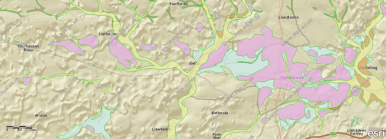
In addition to the patchy spread of fluvio-glacial gravels in the Rosebush - Llangolman area, there is an even more extensive spread some miles further south, in the vicinity of Clarbeston Road, Clarbeston and Clynderwen.
I recall doing some mapping in this area more than 40 years ago, and at that time there were a few small private gravel pits where exposures could be seen. At the time I was in a hurry, and somewhat naive -- I wish I had kept better field notes!
These gravels are spread across the landscape, so they are not fluvial gravels dating from interglacial phases -- they must, I think, be linked to the Anglian Glaciation. The same must be true of the associated till deposits mapped by the GS surveyors. Sid Howells has done some work on these and other gravels -- I look forward to comparing notes with him.
Rosebush Sand Pit
.jpg)
One of the nice things about going back to the original ancient sources (as Myris constantly exhorts us all to do) is that one rediscovers treasures. I had forgotten about this description by Jehu (1906) on the GLACIAL DEPOSITS OF NORTHERN PEMBROKESHIRE. On page 72 he refers to a sand pit a few yards south of Rosebush Station, on the western side of the railway (which no longer exists). showing about 10 ft of sediments, the most interesting of which is a fine yellow sand, "very ferruginous in places" and apparently layered, with patches and "imperfect layers" of blackish hard pan-like material "which is probably organic in nature." This is overlain by 3-4 ft of rubbly material, full of fragments of slaty and other local rocks.
I doubt that the black material is organic -- but it would be interesting to check, if only we could find this deposit again........ We can speculate that the sand layer has discontinuous bands of manganese oxide concretions in it -- just like the black bands in the gravels at Llangolman. We may assume that the two gravel deposits are therefore the same age -- ie probably Anglian.
The overlying bed of "rubble" is perhaps more interesting -- is it a slope deposit? I would doubt that, given the location well away from any steep mountainside or valley side. But just a couple of km away is Foel Cwmcerwyn, the highest summit of Preseli. If there was a Devensian ice cap here for a few centuries, maybe it spread far enough downslope on its western side to have affected the Rosebush area........... in which case the uppermost deposit at Rosebush could be Devensian till.

This is one of the computer-generated images from Aberystwyth suggesting the maximum extent of the Preseli ice cap in the Devensian. Note from the blue square that the ice in the Rosebush area MIGHT have been warm-based for a short time. This would have allowed sliding on the bed and till deposition.
Watch this space.......
Here are three of the several posts I have put up about the Preseli ice cap:
http://brian-mountainman.blogspot.co.uk/2011/08/preseli-ice-cap.html
http://brian-mountainman.blogspot.co.uk/2012/01/preseli-ice-cap.html
http://brian-mountainman.blogspot.co.uk/2010/11/preseli-ice-cap.html
Ancient till at Llangolman?


One of the great things about a blog like this is that occasionally somebody discovers it and makes a contribution out of the blue -- and one thing leads to another........
My previous post:
http://brian-mountainman.blogspot.co.uk/2014/10/pre-devensian-glacial-deposits-south-of.html
Following a comment from Herbert Sauro, I checked out the Wikipedia page on Llangolman, and found this:
From the Wikipedia page on Llangolman:
The area surrounding the village is riddled with steep wooded valleys, presumably cut during one or more of the glacial episodes of the Pleistocene. The village itself sits on a plateau where two valleys meet, the Eastern Cleddau and a tributary that originates near the small village of Llandelio. The underlying geology consists of interbedded Ordovician shales and sandstones with extensive slate outcrops. Evidence of glaciation is also seen from banks of gravel and sand situated to the east of the village which form deep drainage seeps from which discharges excellent spring water.
The springs emerge in boggy land at the base of the gravel banks where deposits of blue boulder clay, known by the natives as "indiarubber clay"can also be found. Clay pits close to the farm houses of Llangolman Farm (still visible) and Llyn are evidence that the clay was extracted on a significant scale at some time in the past. The study by Jehu mentions that the clay pit at Llyn was down to a depth of 15 to 20 feet and ladders were required to get in and out. His report goes on to state that the clay is bluish in color and very tough (hence the nickname indiarubber clay). The clay covers the valley bottom from Llyn to Llangolman Farm at a level of over 400 ft.
Then I dug into my ancient box file of references and found Jehu's seminal paper -- which I used extensively during my own doctorate research. It was written in 1906, and contains much information on the glacial deposits on the southern flank of Preseli.
I look forward to visiting the pit again with Huw Absalom, with a digger in attendance, to see just how thick these gravels are and whether there may be any flowtills exposed lower in the gravel sequence. But Herbert has offered to show me some of the places where he recalls till being exposed in the valley. I have drawn a line roughly around the extent of the till exposure on the air photo above. The little wooded valley in which it occurs may or may not be an ancient part of the Eastern Cleddau drainage system, since we don't know what the bedrock contours are in this area. My impression is that the patches of sands and gravels that stretch from Llangolman north-westwards towards Rosebush have a slightly hummocky appearance in places not because they are Devensian dead-ice features (as in the Moylgrove- Cardigan area) but because they have been deeply eroded over hundreds of thousands of years. If (as I believe) the fluvio-glacial materials are of Anglian age, what we see today may be all that is left of an extensive spread of gravels dating from the ice wastage of the Irish Sea Glacier.
The wooded valley that runs from Llangolman Village towards Llangolman Farm is a strange feature carrying a very small stream and some springs. Could it have been cut by a snowmelt stream during the Wolstonian or Devensian? Such a stream could have cut down through the gravels to expose a thick lodgement till beneath. This till must also be of Anglian age.
For years I have been very sceptical about the idea proposed by Juhu and other early geologists that there were two till deposits in Pembrokeshire, labelled "Older Drift" and "Newer Drift". I'm still convinced that Jehu and Charlesworth mis-labelled many deposits as "Older Drift" which are in fact Devensian in age, particularly in NW Pembrokeshire -- but things are getting clearer, and I am becoming rather sure that there ARE indeed patches of OLDER DRIFT OF ANGLIAN AGE to be found -- perhaps almost exclusively on the southern flanks of Preseli.
Tuesday 16 December 2014
North Sea Mammoth

Mammoth skull being taken ashore in the Netherlands, having been fished up from the floor of the North Sea. Apparently there are lots of bits and pieces out there........ fishermen keep on dredging them up....
http://www.telegraph.co.uk/news/earth/environment/archaeology/11280244/Fossil-hunters-fish-skeleton-of-a-40k-year-old-woolly-mammoth-from-the-North-Sea.html
(BJ Note: the dating of this find seems to be entirely speculative........)
--------------------------
Fossil hunters searching for ancient relics have found the skeleton of a 40,000-year-old woolly mammoth in North Sea.
The team of archaeologists, salvagers and palaeontologists trawled the waters off the east coast of Britain at a depth of 100 feet.
North Sea Fossils, who are based in Urk, Netherlands, include an expert they call "Mr Mammoth" and are in search of the remains of extinct animals in the dark depths.
Bones of animals including woolly rhinos, Irish elks and parts of the male skeleton of an 11-foot tall woolly mammoth, including its skull and tusks, have all been brought up and collected.
A prehistoric skull of a European bison, also known as a Wisent, was also discovered lying on the North Sea bed.
Carbon dating tests revealed the bones belonged to a mammoth that roamed the planet around 40,000 years ago.
Markus Broch, who works at North Sea Fossils, said it is "extremely rare" to find and later assemble a complete mammoth skeleton.
Mr Broch said: "During the Ice Age there was no sea between Holland and England and these great beasts roamed and died there.
"That is why their bones are still found by boats fishing in the North Sea.
"My father-in-law, who is a fisherman, started collecting these bones at young age because he was fascinated by them, and has now assembled a very large collection
"We started selling duplicates from his collection online some years ago, which went so well that our business have grown and grown.
"Most weeks we go to the fishing ports to meet the fishing vessels and buy the fossils they caught.
"Sometimes we charter a boat of our own and go for special 'fossil hunting' expeditions.
"Because we see so many fossils we work very closely with the leading experts in the field, such as Dick Mol, who is the world's leading authority on mammoths.
"We have assembled a number of complete skeletons of mammoths, something very few companies in the world can do."
The salvagers have managed to piece together the entire mammoth skeleton after initially discovering the skull and tusks of the animal in 2012.
The firm travelled out to sea and recovered a stash of other mammoth fossils using deep sea trawler nets before piecing them together at their base in Urk.
Other items found by the firm include parts of sabre-toothed tigers, the skull of a woolly rhino and the cranium of a reindeer.
Mammoths were first described in 1799 by Johann Friedrich Blumenback, a German scientist.
He gave the name Elephas primigenius to elephant-like bones found in Europe.
The bones belonged to the woolly mammoth which was later considered to be a distinct genus and renamed Mamuthus primigenus.
The species found by North Sea Fossils were known to roam through parts of Central Europe around 40,000 years ago.
Monday 15 December 2014
Malaspina Glacier, Alaska

I thought this was worth sharing -- a fantastic image of the famous Malaspina Glacier in Alaska -- a classic example of a piedmont glacier in which the ice has poured out from a narrow trough in the mountains and has expanded into a great lobe on the marine foreland. This glacier has been surging too -- as we can see from the zig-zag pattern of moraines on the ice surface.
The definition on this one (made from Landsat imagery) is amazing -- click to enlarge.
Interview with Jamie Owen

In case you wondered, this is what happens when a big iceberg rolls. You don't want to be anywhere in the vicinity when all hell is let loose, especially if you are in a flimsy canvas canoe and have no survival gear.......
You can listen here (probably in the UK only):
http://www.bbc.co.uk/programmes/b04t9fm1
Cool book on Kindle giveaway

This has nothing whatsoever to do with Stonehenge, but maybe a little bit with the Ice Age........ My new novel entitled "Acts of God", set in East Greenland during the Cold War, is available free (just for 15th and 16th December) in the Kindle version. You have to download it from the Amazon web page, here:
http://www.amazon.com/Acts-God-Brian-John-ebook/dp/B00OGTY17O/ref=sr_1_1?s=books&ie=UTF8&qid=1414853803&sr=1-1&keywords=Acts+of+God+Brian+john
Here are some of the early review comments:
"I finished the book last night. Brilliant!" Gill
"A wonderful, intriguing, spellbinding book. Loved it!" JB"Couldn't put it down! I loved the characterisation of the key players in the story, and the interplay between them as the mystery deepened." Vanya "The plot builds like a great web of deceit and intrigue, weaving around the heroes, drawing them ever onwards and deeper into peril." Allison "Most enjoyable! Brian John gives a new meaning to Cold War." Barrie
" The denouement in the final scene was priceless...... I really enjoyed your detailed and descriptive writing style." Janet"The cold, clinical, cynical and brutal violence perpetrated by both sides and depicted here is shocking, but honest...... The dangers faced by the expedition members become more than risks of natural disaster, and the story becomes compelling." Philip
.......and here's a funny thing. When I was making my web site for the new novel, I was hunting for a suitable domain name and came across this one: actsofgod.cool. Given the topic and the story's location, I had to have it! So in exchange for a few quid, I am now the proud owner, and my web site has the following URL:
http://www.actsofgod.cool
Tuesday 9 December 2014
The Carn Meini "Bluestone Quarry" -- Oh no it isn't! Oh yes it is!


Here we go again. After the recent work by geologists Rob Ixer and Richard Bevins which suggested that the spotted dolerites at Stonehenge have probably NOT come from Carn Meini (Menyn), but from Carn Goedog and other outcrops, Profs Darvill and Wainwright have produced a new paper which suggests that the geologists have got it all wrong, and that there was indeed a quarry here. I venture to suggest that this might well cause some fun and games........
Here is the key info about the paper.
=====================
Beyond Stonehenge: Carn Menyn Quarry and the origin and date of bluestone extraction in the Preseli Hills of south-west Wales
Timothy Darvill & Geoff Wainwright
ANTIQUITY 88 (2014): 1099–1114
http://antiquity.ac.uk/ant/088/ant0881099.htm
Recent investigations at Stonehenge have been accompanied by new research on the origin of the famous ‘bluestones’, a mixed assemblage of rhyolites and dolerites that stand among the much taller sarsens. Some of the rhyolite debitage has been traced to a quarry site at Craig Rhosyfelin near the Pembrokeshire coast; but fieldwork on the upland outcrops of Carn Menyn has also provided evidence for dolerite extraction in the later third millennium BC, and for the production of pillar-like blocks that resemble the Stonehenge bluestones in shape and size. Quarrying at Carn Menyn began much earlier, however, during the seventh millennium BC, suggesting that Mesolithic communities were the first to exploit the geology of this remote upland location.
-------------------------------------------
Let's bring a little critical scrutiny to bear on the text of the paper. On a first reading, these are the things that come to mind:
1. In the very first sentence, the authors refer to the "80 or so" bluestone pillars at Stonehenge which originated over 220 km away in the Preseli Hills. How many times must we repeat that there is only evidence for 43 stones? And how many times must we repeat that not all of them have come from Preseli?
2. Quote: "In July 2012 the authors excavated a trench on the southern flanks of Carn Menyn, Mynachlog Ddu, to investigate evidence of stone quarrying and a dolerite-working area. The investigation revealed a well-preserved stratigraphic sequence spanning the period from before 5000 BC through to 1000 BC that provides secure evidence for pre-Neolithic stone quarrying in the region and absolute dates for the extraction of dolerite pillars from a source outcrop high in the Preseli Hills." Right. That's a pretty spectacular and confident claim -- let's see how well founded it is.
3. The authors cite two key findings from the SPACES project in North Pembrokeshire. First, ".......throughout the study area prehistoric communities had a close relationship with local stone, variously selecting and manipulating blocks for the construction of monuments including portal dolmens, chambered tombs, circles, standing stones, and sometimes just lifting slabs out of the ground as ‘propped rocks’. " Well, that's a statement of the obvious. Every community that used stone in megalithic structures had a close relationship with stone. Nothing special there. Second, "......within the eastern part of the study area our fieldwork supports a suggestion by Richard Bradley (2000: 92–96) that the arrangement of various bluestone lithologies used in the later stages of Stonehenge broadly replicates in microcosm the actual arrangement of stone types across the landscape of the Preseli Hills and surrounding areas. Thus, the dolerites of the Bluestone Horseshoe in the centre of Stonehenge derived from the central Preseli Ridge, while the various rhyolites and tuffs present in the Outer Bluestone Circle originated at outcrops within a wider catchment ......." We can't prove things one way or the other, but this seems to me to be fanciful twaddle. The stones that we know about -- all 43 of them -- were moved about all over the place, and they stood in a variety of settings before the one whose traces we see today. It is far more likely that the use of dolerites in the bluestone horseshoe was a practical matter related to HARDNESS, with the more crumbly and flaky (inferior) stones relegated to the bluestone circle. I find it very hard to believe that every stone at Stonehenge was known to the builders -- many generations after their first use on the site -- as having come from specific Preseli locations.
4. On the matter of dolerite / spotted dolerite origins, the authors take issue with Bevins and Ixer: "......further informed sampling is needed, and Bevin et al’s recent publication can be taken as an alternative rather than a revised interpretation of the Open University’s datasets (Bevins et al. 2014: 181, 192). Moreover, as only around 55 per cent of the 21 Stonehenge samples in the study (including unattributed debris as well as identified extant pillar-stones) can be attributed to a source at Carn Goedog (Bevins et al. 2014: 189), any claim that this was the main source for the Stonehenge bluestones must be treated with extreme caution." I will leave it to the geologists to sort out that particular issue. Plenty of other issues to examine....
5. Quote: "Archaeologically, our surveys show that Carn Menyn was the focus of a great deal of activity in the later Neolithic and early Bronze Age. Burial cairns have been recorded at either end, standing stones on the outcrops, a walled enclosure around the highest point, and natural springheads elaborated through the creation of pools and the occasional application of rock art on the southern side." As I have said before on this blog, I disagree with all of that. Carn Menyn (Meini) was not a focus of any sort, and there is nothing in the landscape to suggest that it was. There are scattered megalithic and other archaeological features right across this landscape in eastern Preseli, and in all compass directions away from Carn Meini. The springheads and "pools" are equally fanciful, and I have seen no convincing evidence that they were either fashioned or modified by human beings, or revered........
6. Quote: "The surveys found that on the southern flanks of Carn Menyn there was a scatter of broken or abandoned dolerite pillar-stones of the same size and proportion as the stones present in the two visible structures at Stonehenge today (see Figure 2), as well as occasional hammer stones." There is an extraordinary diagram -- Figure 2 -- purporting to support this hypothesis, on which stone widths and thicknesses are plotted, but not stone lengths. There is, as you would expect, a wide scatter -- but the most extraordinary feature of the diagram is the plotting of the dimensions of abandoned pillar-stones (some broken) on the slopes of Carn Menyn. This is about as unscientific as you can get. Who chose these stones? Where were they? How many were sampled and how many others were ignored because they were "inconvenient"? As far as I am concerned, this whole exercise is nonsensical.
7. Now we come to the "Carn Menyn Quarry Sequence" -- on page 1103. Note that it is designated as being a quarry before we have even looked at any evidence which might inform our opinions. That appears to be common fault among quarry hunters -- including our friends from the rival tribe who have been digging at Rhosyfelin.
8. With reference to the key "quarrying" site at SN 143324, the authors claim that "....shallow hollows suggestive of quarry pits were also recognised and, on the basis of surface evidence, seemed to be for the extraction of a fine, light-grey coloured meta-mudstone (Darvill et al. 2008). Surface evidence including a broken pillar-stone, intercutting quarry pits and indications of dolerite extraction on a terrace on the southern slopes of Carn Menyn at an altitude of 310m asl........" A 30 sq m pit across the terrace is claimed to show three main periods of activity associated with the working of meta-mudstones and spotted dolerites. It is claimed that the first workings on the site were for the extraction of meta-mudstones, and that there are at least a dozen pits along the edge of a dolerite dyke which are associated with this phase. Darvill and Wainwright claim that fire-setting was a part of the extraction process, and they present four radiocarbon dates on the "abundant charcoal from oak stick-wood" found in the holes. There are two radiocarbon dates from the deepest part of the pit -- 7987 yrs BP and 7711 yrs BP -- which are surprisingly old, and two others, one from 6170 yrs BP and the other from 6396 yrs BP. The authors also claim to have discovered hammer stones and flakes from the quarrying operations, although we are not shown any evidence in support of this contention. On the plan of the site, the authors show stone piles / small cairns (?) and also a spread of meta-mudstone knapping waste and two low-walled huts or shelters (?). They also show three broken dolerite pillar stones and two complete dolerite pillar stones, in an area where scores of stones could have been represented if they had chosen to do so. What should one make of all this "evidence"? Personally, I am not convinced that we are looking at any evidence of quarrying activity in the period 8,000 - 6,000 yrs BP. There are undulations and pits everywhere in this landscape -- as far as I am concerned, they are not noteworthy. We know that parts of these uplands were wooded during the early part of the Holocene, before climate change and grazing caused the woodland edge to retreat downslope. The name "Carn Goedog" means "Woodland Crag" -- and that's rather suggestive of quite a late woodland survival. Could the charcoal have come from natural fires or man-made clearance fires in the woodlands on the ridge crest? Perfectly feasible. Alternatively, we may be looking at charcoal left in fire pits which were used at Mesolithic or early Neolithic camp sites established here in the vicinity of the Carn Meini crags. Why would anybody want to use fire to extract slabs of meta-mudstone when it is so broken and shattered anyway in this area that you just have to walk along and pick it up......?
9. Next, the authors claim to have evidence for "the working of dolerite" in the later third millennium BC. They claim to have found a shallow socket once used for a standing stone, which lies "fallen to the south." They also claim to have exposed packing-stones around the base of the stone, and illustrate this in Figure 7. The base of this stone also supposedly shows a "half-sectioned socket" -- whatever that may be. I find none of this convincing. The "socket" appears to be entirely natural, and the "packing stones" -- carefully left in place while other stones have been removed -- seem to be in quite the wrong positions to have been packed into a socket holding a standing stone. I think we are looking here at yet another archaeological artifice, like those created by Prof MPP and colleagues at Rhosyfelin. "Oak stick-wood charcoal" from the fill of the socket gave three radiocarbon dates of 4188 yrs BP, 3797 yrs BP, and 3724 yrs BP. (Note that these dates are generalised -- the margins of error are cited in the paper.) So what does this tell us? Not a lot, except that there seems to have been a pit here with occasional fires over a few centuries around 4,000 years ago.
10. Next, we have the so-called evidence of dolerite quarrying. Quote: "An area of preserved old ground surface towards the southern end of the trench (see Figure 4 for position) contained a scatter of spotted dolerite flakes and hammer stones with evidence of burning directly associated with it." Once again, we are not shown the evidence -- we are just told that it exists. Not good enough. There are three more dates from this area from oak charcoal, namely 3685 yrs BP, 3673 yrs BP, and 3567 yrs BP. The authors say: "These are the first secure dates for prehistoric dolerite working in the Preseli Hills and clearly indicate that Carn Menyn was being actively exploited in the late third millennium BC." I'm sorry, but I see no evidence at all which supports that contention. All I see -- in the evidence on the ground and in the photos figured in the paper -- is a chaotic jumble of dolerite fragments and "meta-mudstones" dramatically affected by frost shattering and other natural processes, with occasional evidence for the use of fire -- possibly in association with camp sites. We do not know whether the evidence of fires in pits is unique to this area, or whether it occurs in close proximity to all the other rocky outcrops in eastern Preseli.
11. Quote: "The third and final period of activity represented in the Carn Menyn Quarry sequence again relates to the extraction of meta-mudstone. The earlier quarry was more or less silted- up by the end of the second millennium BC, but a new pit appears to have been dug to the south, partly overlapping its ancient predecessor." No evidence is provided by the authors as to the characteristics of these layers, and it is impossible to ascertain whether they are natural or man-made. The assumption seems to be that they are man-made because they are on top of other layers that are also deemed to be man-made -- and we end up in a classic circular argument. There are two charcoal dates from this supposed late phase of meta-mudstone working: 2979 yrs BP and 2871 yrs BP. These are deemed to be related to two other dates -- one from the "large cairn" investigated at the western extremity of Carn Meini (3073 yrs BP) and a date from Croesmihangel not far from Foel Drigarn (3509 yrs BP).
12. In their discussion of the results (p 1109) the authors demonstrate that they have several problems to cope with. They state: "The main stratigraphically determined periods of activity described above appear to be more or less discrete episodes spatially connected by the power of place." Excuse me, but what is that supposed to mean? The assumption is that there were two very early phases of meta-mudstone extraction -- around 9000-8000 years ago and 7800-6000 years ago. Quote: "These early dates make the Carn Menyn Quarry the earliest-recorded securely dated stone extraction site in Britain." I think we will beg to differ on that one, pending the presentation of some convincing evidence. Quote: "On a wider front, the discovery of formal quarrying in the British late Mesolithic adds significantly to the growing list of monuments and structures from this period." A rather grandiose claim based upon the flimsiest of evidence. The authors then seek to link these early dates with similar dates from the Stonehenge landscape: "The extension of the cultural sequence at Carn Menyn back into the sixth and fifth millennia BC brings the pattern of activity there into close accord with what is known of the Stonehenge area, and begins to flesh out the bare bones of parallel but connected developments in the two areas."
13. Quote: "The second main period of activity at the Carn Menyn Quarry also divides into two phases: the erection of a standing stone and dolerite-working. Modelling suggests that the standing stone was set up before the dolerite-working took place....". The modelled date for the assumed erection of the standing stone is between 6,000 yrs BP and 4640 yrs BP -- far too wide a span to be meaningful. The modelled date for dolerite working is between 4,000 yrs BP and 3,800 yrs BP, also with much uncertainty. It will not go unnoticed that this very late date for dolerite working does nothing whatsoever to support the thesis that this was a quarry used for spotted dolerites destined for Stonehenge. While there are subtle differences in interpretation, it now seems to be widely accepted that the bluestones were present in the Stonehenge landscape before 5,000 years BP.
14. Quote: "These findings finally lay to rest the theory that the bluestones arrived on Salisbury Plain through glacial action (Kellaway 1971), an idea that has been remarkably persistent and periodically revived (e.g. John 2008) despite being comprehensively discredited by geologists, geomorphologists and glaciologists more than a decade ago (Green 1997: 264; Scourse 1997; Clark et al 2004; Bowen 2005: 147–48)." Excuse me, chaps, but that is utter nonsense. Which geologists and glaciologists have "comprehensively discredited" the idea of glacial transport? Not one, that I can think of. The only glaciologists who have expressed a view have come down with a statement that glacial transport would have been perfectly feasible. The cited authors are all geomorphologists, and with the best will in the world they have not done any comprehensive discrediting of anything. They have expressed their views, and I respect them, but in my view their arguments are not well supported. Trust me -- I'm a geomorphologist too.
15. The authors argue that there is some significance in the "re-working" of the Carn Menyn site, and in the construction of the Carn Menyn cairn and the Croesmihangel round barrow at the western and eastern ends of the dolerite outcrops. Another extraordinary flight of fancy.......
16. I'll quote the whole of the final paragraph of the paper:
"Many explanations as to why the bluestones were considered sufficiently important and meaningful to move from Wales to Wiltshire can be proposed, and there may be more than one reason. The demonstrable antiquity of stone extraction on Carn Menyn, long before the building of Stonehenge began, tells us something about the ancestral significance and power of the landscape from which the bluestones were taken. Perhaps Mynydd Preseli was the home of the gods: the Mount Olympus of Neolithic Britain. But we also believe that the association between bluestones and healing springs in the Preseli Hills was important (cf. Jones 1992), and something that resonates with long-standing oral traditions that were first written down in the thirteenth century AD (Piggott 1941). Springs were a significant and persistent feature of the Stonehenge landscape, as the recent work at Blick Mead shows (Jacques et al. 2012). Soon after the bluestones were installed at Stonehenge (Stage 2) the central structure was linked by an Avenue to Stonehenge Bottom and the River Avon (Stage 3), thereby fixing and formalising the relationship to water (Darvill et al. 2012a: 1035). The idea that powerful stones were moved from their source outcrops on a special, ancestral or sacred place to ‘franchise’ distant shrines and temples finds parallels in West African societies and elsewhere (Insoll 2006). We propose that, after the earthwork enclosure at Stonehenge ceased to be a major cremation cemetery sometime about 2500 BC, bluestones from Carn Menyn and other nearby outcrops in west Wales were brought to Stonehenge and set up within a temple whose structure had already been built from sarsen stones. From that time onwards, pilgrims and travellers were drawn to Stonehenge because of the special properties that had empowered Stonehenge to provide pastoral and medical care of both body and soul: tending the wounded, treating the sick, calming troubled minds, promoting fecundity, assisting and celebrating births and protecting people against malevolent forces in a dangerous and uncertain world. The bluestones hold the key to the meaning of Stonehenge,
and Preseli was the special place from whence they came at a high cost to society in labour and time, as befitted such important talismans."
The authors are still wedded to the healing springs and healing stones idea, in spite of the fact that there is no evidence in local folklore or archaeology to support the hypothesis, and no evidence of spotted dolerite being specially revered and preferentially used in megalithic structures in North Pembrokeshire.
IN CONCLUSION
Some interesting dates, but whatever went on at Carn Meini, it certainly had nothing whatsoever to do with Stonehenge.
Thursday 27 November 2014
Flat Holm Erratic Hunt (8): some interesting pebbles


Have a good look at these, folks. Picked up on the beaches of Flat Holm by Linda, Sid, Chris and myself -- and all now being analysed by Sid and some of his colleagues.
Some of them look very interesting indeed, suggesting either W Pembs or Anglesey in the frame as possible provenances. Click to enlarge. Watch this space............
Wednesday 19 November 2014
Flat Holm Erratic Hunt (7): the geomorphology

Flat Holm seen from the NW -- in this photo the west side of the island is on the right -- note the overall roche moutonnee form.
As mentioned in earlier posts, Flat Holm is a relatively low island, almost circular, and just over 600m in diameter. There is a gentle slope from the more exposed western shore up towards the eastern cliffs -- and it is on the east that the highest land on the island is to be found. The highest point is only 32m above sea-level, but because the tidal range is so large here -- up to 15m on some spring tides -- the island expands and contracts rather spectacularly every day.......
As noted in earlier posts, the island has an ideal roche moutonnee form which matches perfectly the passage of ice across the island, moving from west towards east on several occasions during the Ice Age. However, it would be a mistake to attribute the form of the island entirely to glacial processes, since the main geological features are a series of pitching anticlines and synclines running broadly NE-SW -- and these features, above all else, explain "the lie of the land." There are extensive exposed bedrock surfaces on the western side of the island between the tide marks. Scrambling about beneath the cliffs is more difficult on the south coast, and more difficult still on the east side of the island, where cliffs and thick vegetation make exploring an occasionally hazardous occupation.
The western side of the island is a geological paradise, with abundant fissures, faults, folds, thrusts and anticlinal and synclinal structures easily accessible -- alongside many variations in rock type. The rocks all belong to the Carboniferous series, but in addition to "classic" hard grey limestones there are also mudstones, cherts, oolites and also veins of calcite and post-Carboniferous weathering and residual products exposed particularly in fissures and gullies in the cliff face.
The most famous surface features are the large ripple marks exposed on the shore platform to the west of the farmhouse. They have been exposed as a result of the breaking up and stripping off of overlying strata -- partly by glacial processes and partly by wave action.

Some of the large ripple structures on the west side of the island. A perfectly preserved Carboniferous sea floor......

Steeply dipping bedrock (mudstones, shales and sandy layers as well as interbedded limestones) near the SW corner of the island. The upper 2m or so of the bedrock exposure is broken up by periglacial and slope processes; there are signs of frost heave features. At the top of the cliff is a thin sandy loam incorporating windblown material. This is probably Holocene. In the gully in the middle distance there is a plug of reddish material which may be of Triassic age; but there is much debate about this.......
Around the whole coast of the island there are traces of a raised beach platform -- or more likely, several of them. Structural controls are so dominant that these fragments are difficult to identify with any certainty -- but they occur at all sorts of altitudes from mean tide level up to about 3m above extreme spring HWM. Trying to match these traces with the raised beach platforms of Pembrokeshire (for example) is very difficult, because of the vast tidal range here in the Severn Estuary. The best preserved raised beach platform is about 2m - 3m above extreme HWM, on the cliffs at the SE corner of Coal Beach. The platform extends towards Point Bay. This is what it looks like:

Sid Howells on the raised beach platform which runs for almost 100m along the cliffs near the eastern extremity of the island. The surface is irregular, but it is a well-pronounced
feature up to 4m wide.
There is also a modern wave-cut platform which is occasionally more than 100m wide, cut by a combination of marine solutional processes and abrasion as blocks and pebbles are moved about by waves and tidal rises and falls. Parts of this platform are well covered with rocky debris and pebbles, but occasionally it might be exposed, as in this photo of Point Bay, as seen from the clifftop near the Foghorn.

Because the whole island is made up of calcareous rocks with complex structures and abundant fissures, it is inevitable that there are tunnels, caves and solutional hollows and collapses all over the place. Some of these have been used for the exploration of past inhabitants for lead and other minerals -- and indeed for the exploitation of mineral finds. Above the raised beach rock platform between Coal Beach and Point Bay, there are two tunnel entrances. It's thought that one of them is natural and the other man-made -- but to me it looks as if both might be natural but maybe enlarged by those in search of mineral wealth. This is the entrance to one cave. It looks very similar to the caves of Gower, South Pembrokeshire and Caldey Island -- and it is quite possible that prehistoric layers might be present and worthy of examination.

Castle Rock is a spectacular double stack with an old cave system at its centre. It is being whittled away by marine processes, and at any moment -- probably during some storm bringing big waves in from the north -- the tops of both stacks will slide into the sea, along old bedding planes which can easily be seen from the beach below.

Finally. a word about the solutional features which are particularly prominent around the southern shores of the island where the massive limestone beds of the Birnbeck Limestone are exposed. We can refer to these features as "karren". They incorporate jagged raised surfaces and complex and intertwining channels which are sometimes almost a metre deep. mechanical abrasion does not seem to be very active in most cases- these are straightforward solutional features. The edges of the ridges are often razor-sharp -- capable of ripping boot soles to shreds, not to mention hands, if you are unwise enough to lose your balance when hopping around on the ridges........

Conclusion: Plenty of geomorphology to get your teeth into here, not to mention classic geological features. Interestingly enough, Sid, Chris and I did not identify a single in situ glacial or fluvio-glacial deposit on the island cliffs. That confirms, in my mind, that Devensian ice probably did not reach Flat Holm. But there are erratics everywhere, and in several places we see deposits that look like very ancient glacial deposits that have been eroded and modified over a long period of time. The best guess is that they are Anglian in age, and that it was the Anglian Glaciation that carried those thousands of erratics from the far west into the vicinity.
Tuesday 18 November 2014

Monday 17 November 2014
Vyrnwy excavations 1882

This fantastic 1882 photo (from the Hubbard Collection) has just been released by Heritage of Wales News. It shows the sheer scale of the excavation work that went in to the creation of the dam which flooded a whole community and created a huge new water supply lake. But it also shows in amazing detail the glacial geomorphology of the area, with the superficial deposits stripped off and the jagged bedrock surface beneath exposed so as to create a firm foundation for the masonry dam. This is apparently the SW end of the vast excavation trench. The deposits are here about 16m thick and seem to consist of relatively fine-grained materials at the base (fine-grained till?) overlain by a more pebble layer and then by something that looks like a major unconformity, and some flat-lying sediments about 2 m thick above that. That's all a bit speculative. I wonder how these sediments were described by the engineers of the day? And the bedrock surface.. In places it looks distinctly moulded or streamlined -- but there is clear structural control here, so it would not be very wise to speculate too much......

This photo shows the completed dam before the lake was filled.
Friday 14 November 2014
Yet another Stonehenge experiment

A pic from the previous experiment. Photo: Tim Daw
Another Stonehenge experiment coming up...... The appetite for Stonehenge stories is insatiable. And yet another BBC Stonehenge spectacular is apparently planned. You'd have thought people would be fed up by now with "Stonehenge mystery finally solved" stories, but onwards and upwards it all goes.....
Stonehenge experiment to be repeated with ‘lost’ stones
Another attempt is to be made to solve the mystery of how the largest stones used to build Stonehenge were moved.
The experiment was first carried out in a BBC documentary in 1996
In 1996, a BBC TV programme aimed to find out how the stones for the largest trilithon were put into place, and how the lintel was placed on top.
Since then the concrete replicas have remained untouched and forgotten about at an army base on Salisbury Plain in Wiltshire.
They have now been rediscovered and the experiment will be repeated.
Archaeologist Julian Richards is teaming up with farmer Tim Daw see if modern techniques are any more efficient.
Mr Daw, who farms at All Cannings, near Devizes, and who created the first "Neolithic" long barrow to be built in the UK for 5,500 years, also works part-time at Stonehenge.
He said one of the most popular questions asked by visitors is 'how were the giant stones moved?'.
"When Julian Richards mentioned there was a life-sized replica of the largest stones at Stonehenge that were looking for a home that we could do some experiments on I said 'let's do it'."
The 45-tonne replicas were used in the BBC documentary Secrets of Lost Empires: Stonehenge, which was broadcast in 1996.
They have remained at Larkhill Camp, about a mile from Stonehenge ever since.
The experiment was partially successful, but now new theories have emerged about how the stones may have been moved.
"The first thing is to collect the stones from Salisbury Plain where they have been languishing for the past 20 years and get them back to my farm," said Mr Daw.
"Hopefully next year we'll get some teams of people [to take part in the experiment]"
Mr Daw said different theories had now emerged about how the huge stones could have been moved.
"The experts certainly think they know more. Whether they actually do know more is an interesting question.
"Without trying all the wonderful ideas of how you do it Neolithic style, just using man power - no wheels, no draught animals, no machinery - we can't tell what is practical and what is just fantasy."
It is hoped the result of the experiment will be turned into another television programme to air next year.
http://www.bbc.co.uk/news/uk-england-wiltshire-30041330
Saturday 1 November 2014
Acts of God -- available as from now

Excuse me, ladies and gents, for posting something rather erratic (if Stonehenge and the bluestones are the things that keep you awake at night) -- but herewith a bit of shameless promotion........
The cover is designed, the book is printed, and I expect delivery on Monday. Here is the blurb:
Eight members of a scientific expedition arrive in the Arctic wilderness of East Greenland at the height of the Cold War. At the same time the inhabitants of a remote Inuit village are evicted from their traditional hunting grounds. As one Act of God follows another, both the explorers and the Greenlanders become the unwitting guinea pigs in a series of grotesque experiments. The death toll mounts. Bit by bit, the victims uncover a global conspiracy, and realize that an implacable enemy with limitless resources will not allow any of them to survive.
And the good news is that if anybody wants to order a copy, either for the Kindle or paperback version, it can be done via this web site:
http://actsofgod.weebly.com/
I have been forced to stick it into a genre, so you'll see it advertised as an action thriller / conspiracy / mystery / adventure book. But I'm not all that happy with labels like these. I like to think that this book has rather more depth to it than most modern thrillers, and that characterization and location are as important as frenetic action and violence.
Anyway, if anybody gets to read the story, hope you enjoy it! And as ever, please like it, rate it, and stick your reviews onto the Amazon web site so that it can struggle into the "top million bestsellers" list........
Thursday 30 October 2014
EH makes monographs available for free
Good for EH -- they have just made a long list of research monographs available for free download. Some very interesting materials is included in the list........
http://archaeologydataservice.ac.uk/archives/view/eh_monographs_2014/index.cfm?type=Date
Abermawr -- one of the top 50 Quaternary sites in the UK?

The deformed contact between underlying periglacial slope deposits of Early / Middle Devensian age, and the overlying Irish Sea till, laid down by Late Devensian ice moving onshore from the north-west
The QRA (Quaternary Research Association) is asking all its members for nominations for the "top 50" Quaternary sites in the UK. I have nominated Abermawr -- it has to be up there with the best!
Here is my citation:
This is the most comprehensive exposure of Late Pleistocene deposits in West Wales. There are exposures at both ends of the bay. Storms have revealed an Ipswichian raised beach on a rock platform remnant, and above that there is a sequence of periglacial deposits made up of angular bedrock fragments, but incorporating far-travelled erratics. Above that is a clay-rich Irish Sea till of Late Devensian age and containing striated clasts, fragments of carbonized wood and sea shells. The main components of the till are sea-floor deposits, dredged up by glacier ice moving across the old coastline and later laid down by lodgement and shearing. There are also flow-tills, and the glacial deposits are capped by fluvio-glacial materials, an upper head (referred to in the past as “rubble-drift”), sandy loam and modern soil. The deposits represent a complete advance/retreat cycle close to a glacier margin. In the upper head there are fossil ice-wedges and involutions of Late Glacial age. Beneath the storm beach there are peat beds and remnants of the “submerged forest”, and these organic-rich sediments can be examined in the marsh on the landward side of the storm ridge. There is a continuous stratigraphic record here, probably stretching back c 100,000 years.
Rijsdijk, K and McCarroll, D. 2001. Abermawr, in The Quaternary of West Wales Field Guide, QRA, pp 32 - 38.
John, BS 1970. Pembrokeshire, in Lewis, CA (ed) The Glaciations of Wales and Adjoining Regions, pp 229-265
Wednesday 29 October 2014
Was Cardiff Bay affected by Devensian ice?

With reference to my earlier post about the position of the Devensian ice front on the southern flank of the Welsh Ice Cap, there is still disagreement among geomorphologists.
This section of the BRITICE Devensian map shows abundant glacial / fluvioglacial deposits in the Cardiff - Newport area, but the compilers of the map decided that the Vale of Glamorgan was ice-free at this time, as was the coastal stretch to the east of Lavernock point. The dotted line on the map shows the assumed maximum ice front position.
In contrast, Devensian ice lobes are assumed to have reached the Bristol Channel lowlands (ie beyond the present coastline) both in Swansea Bay and Carmarthen Bay.
My earlier post is here:
http://brian-mountainman.blogspot.co.uk/2014/10/flat-holm-erratic-hunt-6-lets-imagine.html
The extensive spreads of ice-related deposits shown on the map were assumed by Charlesworth in 1929 to represent the position of the South wales End Moraine, but it's now known that things were much more complicated than that. Some of the deposits on the map are Devensian, and some may well be much older....... In some of the reconstructions by Prof DQ Bowen over the years, he has an ice lobe pushing offshore between Cardiff and Newport, and in others the lobe fails to reach the coast. Work in progress?
Saturday 25 October 2014
Mystery
Just been alerted to the fact that 1470 people have looked at this blog post about braided rivers in Iceland......
http://brian-mountainman.blogspot.co.uk/2014/05/braided-rivers-in-iceland.html
Well over 700 have looked at it today -- I wonder why? Does anybody else have any idea what's going on? Admittedly, they are very beautiful images......
http://brian-mountainman.blogspot.co.uk/2014/05/braided-rivers-in-iceland.html
Well over 700 have looked at it today -- I wonder why? Does anybody else have any idea what's going on? Admittedly, they are very beautiful images......
Tim's Long Barrow opens for business

Tim's long barrow is open for business -- and if you want to take a look, get over there right now!! More info here on the BBC web site:
and here, on Tim's site:


Wednesday 22 October 2014
BRITICE map of Pembrokeshire's old glacial deposits

This is the relevant piece of the BRITICE map of glacial deposits and other features relating to the Last Glaciation. It's a few years old now, and new information has made parts of it look dated, but it was the state of the art summary when it was published, and it's still a valuable aid to future research. The whole map is in two sections available for download -- northern and southern sheets. This extract is from the southern sheet.
The map shows the area assumed to have been ice-free in the Devensian (faint yellow colouring), main spreads of fluvio-glacial gravels (brown), proglacial lakes (blue), meltwater channels (dark blue), glacial limits (dotted lines) and assumed ice dam positions (yellow lines).
Let's forget about the north Pembrokeshire features for the moment and concentrate on those of central Pembrokeshire. The patches of glacial deposits (gravels and till) shown are generalised from the BGS Geology of Britain map at the 1:50,000 scale. Those of the Western Cleddau valley are well shown, as are the sand and gravel patches to the east of Haverfordwest, in the Clarbeston Road - Clynderwen area. But the patches to the north, in the foothills of Preseli, are not shown, probably because they are not extensive enough. But they are rather intriguing, as I suggested yesterday. What do they tell us about the glacial history of West Wales? I'm on the case......
http://mapapps.bgs.ac.uk/geologyofbritain/home.html
http://www.britice-chrono.group.shef.ac.uk/current-sampling-map/
http://www.sheffield.ac.uk/polopoly_fs/1.22760!/file/britice_2004_s.pdf
Subscribe to:
Posts (Atom)