THE BOOK
Some of the ideas discussed in this blog are published in my new book called "The Stonehenge Bluestones" -- available by post and through good bookshops everywhere. Bad bookshops might not have it....
To order, click
HERE

Friday 30 January 2015

Folk memories of the Holocene sea-level rise


There's an interesting article doing the rounds today which argues -- very convincingly -- that Aboriginal stories about "lost lands" off the coasts of Australia cannot have been fabricated or passed on from one group to another, given the enormous distances which separate the various tribal areas.  On that basis, argue the authors, we must have an actual folk memory transmitted in the form of stories over thousands of generations -- going back maybe 13,000 years.

Another point made by the authors is that these stories (based on the post-glacial or Holocene inundation from -120m to more or less present-day sea-level) do not relate to flood stories (like the Biblical Noah's Flood) since they all tell of a PERMANENT loss of land, not a temporary catastrophic inundation.

All very interesting.  Where I part company with the authors is over the matter of how unique these Aboriginal stories are.  They may be unique to the United States and Australia, but in Europe that are by no means uncommon.  Atlantis, Dogger Land etc.........  and the best story of all is of course the tale (or tales) of the Lowland Hundred or Cantre'r Gwaelod in Cardigan Bay, inundated by a rising sea level and never recovered.  I have discussed Cantre'r Gwaelod and the submerged forests of Wales on a number of occasions.  See here, for example:

http://brian-mountainman.blogspot.co.uk/2011/04/inundation-of-cardigan-bay-oldest-story.html
The inundation of Cardigan Bay -- the oldest story in Wales?
http://brian-mountainman.blogspot.co.uk/2014/02/did-our-ancient-ancestors-have-chain.html
http://brian-mountainman.blogspot.co.uk/2014/03/newgale-submerged-forest-2014-exposures.html


and this is a good summary in Wikipedia:

The folk memory of Cantre'r Gwaelod
http://en.wikipedia.org/wiki/Cantre%27r_Gwaelod
-----------------------------


Deep time: Aboriginal stories tell of when the Great Barrier Reef was dry land
Nick Reid & Patrick Nunn
29th January 2015
The Ecologist


Stories told by Australia's Aboriginal peoples tell of the time, over 10,000 years ago, when the last Ice Age came to an end, and sea levels rose by 120 metres, write Nick Reid & Patrick Nunn. The narratives tally with the findings of contemporary science, raising the question: what is it about Aborigines and their culture than so accurately transmitted their oral traditions across thousands of generations?

http://www.theecologist.org/blogs_and_comments/Blogs/2711943/deep_time_aboriginal_stories_tell_of_when_the_great_barrier_reef_was_dry_land.html

http://research.usc.edu.au/vital/access/manager/Repository/usc:14264?queryType=vitalDismax&query=indigenous+australian+stories

Indigenous Australian stories and sea-level change

Reid, N
Nunn, Patrick
Sharpe, M

Abstract

Oral traditions, especially contrasted with written history, are typically portrayed as inaccurate. Commenting on native title claims in the US, Simic (2000) made the specific claim: “As a general rule, unwritten legends that refer to events more than 1,000 years in the past contain little, if any, historical truth”. So can preliterate Indigenous languages tell us anything factual about the distant past, or does the transmission of historical facts become inevitably corrupted? Changes in sea levels around the Australian coast are now well established. Marine geographers can now point to specific parts of the Australian coast and know with some confidence what the sea levels were at a particular time before the present. This paper reports on a substantial body of Australian Aboriginal stories that appear to represent genuine and unique observations of post-glacial increases in sea level, at time depths that range from about 13,400–7,500 years BP. This paper makes the case that endangered Indigenous languages can be repositories for factual knowledge across time depths far greater than previously imagined, forcing a rethink of the ways in which such traditions have been dismissed.

Thursday 29 January 2015

Testing to destruction

Carngoedog, Carnmeini and Craig Rhosyfelin -- wonderful spots for picnics and maybe a bit of hunting.... but are they quarry sites?  Hmmm....

We all enjoy a bit of knockabout fun on this blog, and I like to think we are testing the glacial transport hypothesis to destruction.  If it stands up, fine, and if in the end it falls, that's fine too, since the truth will out........

But I don't see much evidence from anywhere of the archaeologists testing the human transport hypothesis to destruction.   Is that debate going on, somewhere behind the scenes?  Or is there a sort of orthodoxy that prevails, and woe betide anybody who strays into the realms of blasphemy?  One has heard rather sad tales of diggers at Rhosyfelin being hauled over the coals  by the powers that be, for daring to question some of the tenets of belief of the high priesthood -- are those tales true or false?

Let's help the process along by asking the archaeologists to address these particular issues and to do a little testing to destruction on this blog, or maybe somewhere else........

Why the obsession with quarry hunting, in the light of all this:

1.  There is no sound evidence from anywhere in the British Neolithic / Bronze Age record of large stones being hauled over long distances for incorporation in a megalithic monument.

2.  The builders of Neolithic monuments across the UK, as a general rule, used whatever large stones were at hand.

3. If ancestor stones were being transported to Stonehenge, why have all of the known bluestone orthostats come from the west, and not from any other points of the compass?

4.  There is no known evidence either from West Wales or from anywhere else of bluestones (for example, spotted dolerite or rhyolite) being used preferentially in megalithic monuments, or revered in any way.

5.  If long-distance stone haulage was "the great thing" for the builders of Stonehenge, why is there no known evidence of the development of the appropriate haulage technology leading up to the late Neolithic, and a decline afterwards?  It is a complete technological aberration.

6. The evidence for quarrying activity in key locations is questionable, to put it mildly.  The Carn Meini "quarry" has now effectively been ruled out by the geologists.  Rhosyfelin next?

7.  The sheer variety of bluestone types  (I still insist the figure is somewhere near 30) argues against selection and human transport.  There cannot possibly have been more than ten "bluestone quarries" scattered about West Wales.

8.  No physical evidence has ever been found of ropes, rollers, trackways, sledges, abandoned stones, quarrymen's camps, or anything else that might bolster the hypothesis.

9.  Bits and pieces of experimental archaeology on stone haulage techniques (normally in "ideal" conditions) have done nothing to show that our ancestors could cope with the sheer physical difficulty of stone haulage across the heavily-wooded Neolithic terrain of West Wales (characterised by bogs, cataracts, steep slopes and very few clearings) or around the rocky coast.  Aubrey Burl made this point forcefully many years ago, and it remains forceful today.

10.  And if there was a "proto-Stonehenge" somewhere, built of assorted local stones and then dismantled and taken off to Stonehenge, where was it?  Herbert Thomas thought it might have been near Cilymaenllwyd (south of Preseli) and now MPP thinks it might have been north of Preseli, either at Waun Mawn or Castell Mawr).  Again, no known evidence.......

---------------------

PS. I am trying to avoid the use of that horrible expression "There is no evidence......."  That phrase is the curse of the scientific literature.  It is used as a throwaway line by scientists of all descriptions just to make them sound authoritative and to bolster their arguments.  No doubt I have done it myself, very often.  How many people who have used the phrase have found it returning to haunt them or to bite them on the backside, when somebody comes along and shows that the evidence was there all the time, unnoticed?

What we should actually say is "There is no known evidence......"  or  "There is nothing in the literature to suggest this or that......." or even "There is no unequivocal evidence...."  or  "There is no sound evidence....."  That would all be rather more honest, and would avoid future embarrassment!

Wednesday 28 January 2015

Winter wonderland


Another quirky ice phenomenon.  This photo, from the BBC web site, shows "mini icicles" adjacent to a road in Herefordshire during the recent cold weather.  What has happened, apparently, is that a puddle on the adjacent road as been driven through by many cars, splashing water droplets onto the hedge and fence at the roadside.  Because of the sub-zero temperatures, these droplets have frozen on contact or shortly thereafter, and this is what has created these icicle formations.  There is a certain amount of randomness, as you might expect, and more of the drops have hit the lower part of this eccentric ice sculpture, with gravity then playing its part as the moisture has run down each icicle, growing some of them to lengths of almost 20 cms.  Hallelujah!  isn't nature wonderful?

Monday 26 January 2015

Worth knowing, or not?


I found this rather entertaining -- relevant maybe to our current discussion on whether archaeology, history and museums are worthwhile in the great scheme of things!

Perhaps we should investigate whether archaeologists, not archaeology itself,  are worthwhile......

Sunday 25 January 2015

Stonehenge Lecture -- 31st January


News of a new lecture at the end of the month.  Happy to give it some publicity,  and happy to publish any reports from anybody who manages to go along........

It looks as if this is largely to do with more accurate surveying and recording and with the "visualisation" of the landscape -- so I'm not sure what this will throw up in the way of important new information which will increase our understanding of what went on, and why.    Anyway, let's wait and see......

LECTURE: The Stonehenge Landscape – 31st January

by stonehengenews

There will be a lecture by Sharon Soutar of English Heritage at Devizes Town Hall, Wiltshire, England from 2:30 pm on Saturday, 31 January 2015. 

With the construction of the new Visitor Centre at Airman’s Corner it was vital that Stonehenge and its surrounding landscape were re-presented with the fullest and most up-to-date information available. Fantastic as it may seem very few of the monuments, not even Stonehenge itself, had been surveyed to modern standards. To rectify this English Heritage set up a project to significantly enhance the record and understanding of all upstanding archaeological monuments within the World Heritage Site. The fieldwork was conducted between 2009 and 2012 and the book is nearing publication, while a number of research reports on the different areas are available through the website (see below).

The fieldwork covered just over 15% of the World Heritage Site in detail. It included Stonehenge, the Greater Cursus and all of the principal barrow cemeteries and incorporated sites later in date, such as the medieval settlement earthworks at Lake. English Heritage surveyed almost half of the known or suspected round barrows within the WHS; nearly all of those surviving as earthworks. At the same time colleagues looked at the historic buildings, added high resolution Ground Penetrating Radar [GPR] to complement earlier geophysical surveys and took new photography of the landscape and artefacts found within it. ~English Heritage also commissioned a laser scan of the stones and surrounding henge.

Sharon will describe some of the important discoveries resulting from the project and take a look at the more surprising aspects of the field archaeology in the Stonehenge landscape.

Sharon is a landscape archaeologist specialising in the survey and visualisation of heritage landscapes and data; from maps and site plans right through to infographics. After a number of years interpreting and mapping archaeology visible in aerial photographs and lidar data for different parts of England she was lucky enough to join the team investigating the Stonehenge WHS landscape.

The project webpage is: www.english-heritage.org.uk/professional/research/landscapes-and-areas/archaeological-field-survey-and-investigation/stonehenge-landscape/

The project monograph is due for publication in the spring of 2015:
Bowden, M.C.B., Soutar, S., Field, D.J. and Barber, M.J. forthcoming. The Stonehenge Landscape. Swindon: EH.

The 1:10,000 scale map - Stonehenge and Avebury: Exploring the World Heritage Site is available in our shop www.english-heritage.org.uk/publications/stonehenge-avebury-map

The various Research Department Reports are available through: research.english-heritage.org.uk

Booking:
Essential. To contact us, either:
* Tel: 01380 727369 to book and pay using credit/debit card (Monday to Friday 10am to 5pm preferred)
* Send an e-mail
Visit the Wiltshire Museum website: http://www.wiltshiremuseum.org.uk/events/index.php?Action=2&thID=972&prev=1

Thursday 22 January 2015

Whatever happened to Rhosyfelin?


Time for another gripe.  After four seasons (2011-2014) of excavations at this site by Mike Parker Pearson and his team, all we have to show for it is a terrible mess. (This photo was taken shortly after the end of the 2014 dig; God knows what it looks like now.......)

There have been no published excavation reports, no published radiocarbon dates, no peer-reviewed articles, and nothing at all for interested parties to analyse and discuss.  Assorted pop articles and a chapter in MPP's book are no substitutes for proper reporting and informed discussion.

In place of scientific rigour we have seen endless press releases, media coverage and hype, and evening lectures in the 4 village halls in the local community -- and that's all we have in exchange for thousands of pounds of taxpayers' money.

Has anybody ever done a cost / benefit analysis on all of this?

Does anybody know anything?  What on earth is going on?

Wednesday 21 January 2015

The Sleek Stone


Nothing to do with erratics!  Worth sharing.  This is for geology buffs -- the stripped-out core of the pitching monoclinal fold of Sleek Stone, Broad Haven, Pembrokeshire.  A real text-book landform......  the barnacles cover that part of the feature affected by the tides each day.  Almost certainly the "stripping out" of broken blocks of sandstone and shale has been done entirely by wave action in this exposed coastal location.

Erratic pebbles - Abermawr and Flat Holm


Since we are on about erratic behaviour just now...........here we have a nice little collection of small pebbles (up to 3 cms in length) from Abermawr and other North Pembs beaches.  These are on the Cardigan Bay coast.  We can assume that there is nothing here from Ramsey Island and the outer end of St Davids Peninsula -- although one or two do look similar to some of the pebbles I saw yesterday on the beach near Sleek Stone.  Note that these pebbles are wet......


 This is a photo of the beach on the east side of Flat Holm -- mostly limestones and other Carboniferous rocks, but if you click to enlarge, you'll see some igneous material in there too.....


 And this is the collection on the windowsill of the farmhouse on Flat Holm -- collected by Linda and others.  Varied and colourful, as as we might expect, from a wide variety of sources.  Sid Howells staggered off the island back in October with a much more comprehensive collection in his rucksack -- and we look forward in due course to seeing what treasures might be included.

We might expect a collection of pebbles from the Croyde - Saunton area to be similar -- although of course we would expect to find some pebbles exclusive to North Devon.


Croyde - Saunton - Baggy Point erratics list

 Grateful thanks to Paul Madgett for permission to reproduce these two tables, from his 1987 paper written with Ann Inglis.  NB the 37 erratics listed are all classified a "boulders" with 25 cm or more on the longest dimension; Paul has mentioned that there are many more smaller cobbles and pebbles which have been found in the area, on the beach and in head deposits.

The creation of the list in Table 2 is all down to enthusiastic searching by two families -- with Abigail and Barnaby being rewarded with a stick of rock for every new and verified erratic discovered......

As it says in the Good Book -- "Seek and thou shalt find......"  I was struck by that yesterday, when I was grovelling around in the sleet and rain down at Broad Haven!

Tuesday 20 January 2015

A Sleek Stone super-erratic?

The more I think about this, the more convinced I become that there was a single "super-erratic" in approximately the position now occupied by erratics 1 and 2 on my little list.    One reason for this is the fact that Cantrill and colleagues (in 1916) only referred to ONE erratic here, whereas today there are obviously two, made of the same material.  The second reason is the appearance of the erratics  -- blocky, rather angular and showing few of the "sub-rounded" forms often associated with glacially transported blocks. Look at these photos:


The rucksack rests on a relatively clean fracture face with a very sharp edge.  The smaller boulder is on the left.  Beware -- the smaller boulder to the right of the rucksack is not igneous.  It is a boulder of flaggy sandstone which has come from the cliffs nearby.


One of the more rounded (and ancient?) faces of the large erratic.  Notice that there has been a loss of a large chunk of rock from the top surface.


 The smaller erratic boulder -- remarkable for the sharpness of its edges.  Note that the left face appears less weathered than the others.


End-on view of the large erratic (and the local sandstone boulder to its left).  But note the large fracture running across the igneous "super-erratic" -- maybe it will disintegrate further, before too long........


Erratics 1 and 2 sitting on the bedrock platform.  Forget about the local boulders in the foreground.  It looks as if there are 3 erratics here on the rock platform -- but the apparent smaller one covered in barnacles, closest to the camera, is in fact still joined to erratic 1.  For how much longer?

I'm going to stick my neck out here and suggest that in 1916 there was a super-erratic weighing between 95 and 100 tonnes here, and that it has subsequently been broken up into at least two pieces.  Was the damage done during the tremendous storms of January 2014?  We know that much of this coastline was transformed at that time -- with about 2m of sand stripped away from local beaches, leading to exposures of the submerged forest.  I think the monster erratic broke up earlier than that -- since there are no REALLY fresh fracture faces visible at the moment.  I'd like to go back -- I think there may be some more chunks from this super-erratic waiting to be discovered.....


Two more Sleek Stone Erratics

I'm rather intrigued by the top two photos here -- these are both erratic pebbles from near Sleek Stone.  I'm interested by the dark matrix and irregular rather jagged inclusions which make it look like an agglomerate of some sort... or is it an ignimbrite?  The inclusions, when eroded on the surface of the stone, have an almost silky feel to them.  And the colour is unusual too -- with subtle variations on the rosy pink / cream / foxy brown ens of the scale -- very different from the blues, greens and greys of most of the igneous rocks found on local beaches.

These pebbles remind me of the stones found at Aber Mawr and on Newport Estuary in the past:
http://brian-mountainman.blogspot.co.uk/2014/10/another-mystery-erratic-from-abermawr.html

For comparison, I've added the bottom photo of the rough conglomerate boulder found by Chris on Flat Holm in October.  The colouring is similar, but the texture and the nature of the inclusions are quite different.

Any ideas, anybody?


Other Sleek Stone Erratics (1)

Stone No 4 appears to be different from the others -- and I wonder if it is a diorite?  I'd like to take a look at it in the company of an expert geologist, when the sun is shining!

It has the same greenish colouring, but the texture is much coarser, and there don't seem to be obvious phenocrysts -- just a jumble of minerals, many of which have dark elongated crystals.....  opinions please?


And below is a photo of some of the beach pebbles that are scattered about in abundance all over the beach to the north of the Sleek Stone.


Some of these (the greenish and bluish speckled pebbles) look familiar -- and are related to the Giant Erratics -- but we also have a pebble of Cambrian red sandstone here, and the larger pebble to the right of it looks as if it might be gabbro from St David's Head.

Sleek Stone Giant Erratics (3)


Jagged rock fragments, knocked off the edges of giant erratics 1 and 2, compared with a pebble found on the beach nearby.  They all look very similar......


The base of giant erratic No 2, showing the same "speckled" texture.  Below the hammer is the smooth sandstone surface of the Lower Coal Measures.

Sleek Stone Giant Erratics (2)


Close-up of the texture of giant erratic No 5. From a distance the colour appears greenish-blue.


Close-up of the texture of giant erratic No 3.  This one has a more distinct green colouring.

Would anybody like to hazard a guess at the rock type?  Is this what we would call a quartz-porphyry, or two of them?  Or has it got a different name nowadays?  Rhyolite with feldspar phenocrysts?

The Sleek Stone Giant Erratics (1)


Two giant erratics (from Ramsey Island?) resting on a rough platform of  Lower Coal Measures sandstones and shales.  The degrading cliff face is in the background, and the boulders in the foreground are all locally derived.  The larger boulder is about 3m across, and the smaller one about 2m across.  They lie about 100m from the Sleek Stone, and are apparently unmoved since they were described in 1916.

I had a jolly trip to Broad Haven this morning since there was a very low tide at a convenient time -- and although the temperature was just above freezing, with rain and sleet and a high wind, mission accomplished.  The big boulder of "columnar blue quartz-porphyry" discovered by Cantrill et al a century ago is still there, and is still washed by the tides every day.  It's the size of a small caravan -- by far the biggest erratic I have ever seen in Pembrokeshire.  It's got a very irregular shape, and is not at all smoothed or rounded off by either glacial transport or wave action.  It's difficult to estimate its volume, particularly in the middle of a deluge, but I would say it's at least 27 cubic metres -- which would make its weight about 75 tonnes.  (For comparison, the Freshwater Gut erratic is said to weigh about 50 tonnes......).

Next to it is a smaller boulder with an estimated weight of about 22 tonnes.  It's made of the same material, as far as I can see -- so is probably from the same source.  Maybe it has broken off the larger chunk of rock during or after glacial transport.  The colouring is dark blue, but there is heavy weathering on the rock surface.

That's not all.  I found another three giant erratics within 50 m of the ones pictured above,  and the satellite image below has been annotated to show their positions. 

Sleek Stone and the locations of the five giant erratics shown in the photos.


Giant erratics 3 and 4 (the rucksack lies between them) in the bay north of Sleek Stone, Broad Haven.  the degree of rounding on these is much greater, but this may be because of their position lower on the beach, where they are submerged by water for most of the time.  In this part of the shore zone there is a great deal of abrasion going on.....


This is giant erratic No 5 -- the closest one to the Sleek Stone.  This one is easily spotted, because it is standing rather than lying.......  the glove gives the scale.

These three erratics have similar textures to the two biggest ones, but the colour is greenish rather than dark blue.

I am sure there must be other erratics from the same source on this beach -- and I shall return one fine day in the spring or summer, when the rocks are not quite so slippery.

Monday 19 January 2015

Stone 69


Specially for Kostas -- here are the 2 pics from the Atkinson EH collection.   When I used the top one before I omitted to label it properly.  Anyway, I agree it is seriously weird.  Over to you to give us your discourse......

The biggest erratic in Pembrokeshire?


 The Sleek Stone -- a famous monoclinal fold in the Lower Coal Measures.  The erratic is to the north of this little peninsula -- best approached at low tide......


On thumbing through those Geological Survey Memoirs, I discovered a note in the Milford Memoir about a giant erratic beneath the cliffs of Broad Haven (the one on St Bride's Bay) made of "columnar blue quartz-porphyry" and derived almost certainly from Ynys Bery / Ramsey Island.  Its dimensions are approx 3m x 3m x 3m -- which would make it a 50-tonner by my estimation -- and comparable to the giant erratic at Freshwater Gut, near Croyde in Devon.  It's located about 100 yards north of the Sleek Stone, Broad Haven.

I have never seen it myself, but I feel an expedition coming on.........

The Sleek Stone is at the south end of this satellite image, and the giant erratic must be in the bay which we see here in the centre of the photo.

Ramsey Island as a major source of erratics?


I have been struck, in my recent reading, by the number of times that Ramsey Island gets a mention as a possible erratic source.  Most recently I was looking at the paper by Bevins and Donnelly about the Storrie collection of erratics that were gathered up from the Pencoed area of Glamorgan.  They describe a number of sub-rounded fragments made of "mud-rich volcanic debris-flow" material and assign Ramsey Island as a possible source.  They also describe other rock types (gabbro and rhyolitic tuff) from the adjacent St David's Head area.  They also describe three "far-travelled boulders" from the Cowbridge area which are ignimbrites very similar to those found on Ramsey.

Add to this Sid Howells's instinct that quite a few of the erratic pebbles collected on Flat Holm are from Ramsey (still to be confirmed by detailed analyses)...........

And add to this the speculation as to Ramsey origins for some of the more unusual erratic pebbles and boulders collected by the Geological Survey field researchers in the period 1904-21.

Griffiths (1940) identified two erratic types in south Pembrokeshire that he traced to Ramsey Island.

Finally there are the suggestions -- in my mind at least -- that some of the far-travelled erratics on Lundy Island and in the Baggy Point - Croyde - Saunton area might also have come from Ramsey.  Much more thin-section work is needed!

Should we be surprised if Ramsey Island turns out to be rather an important source for far-travelled erratic material?  Not a bit of it.  If Irish Sea Ice was coming in from St George's Channel -- ie from the north-west --  at a time when there was no sea water in the vicinity at the time, ice would have been rising up from a bedrock floor beneath -100m OD to override the western cliffs of the island which are over 100m high.  So ice would have been flowing UPHILL on quite a steep gradient, from NW towards SE, over a distance of not much more than 20 km, and rising 200m (c 660 ft) in the process.  Perfect conditions for compressive ice flow, and perfect conditions for the entrainment of erratics.

The Glaciation of South Pembrokeshire


On hunting through some old box-files I have rediscovered photocopies of the "superficial deposits" chapters from the Memoirs of the Geological Survey, published between 1909 and 1921.  The surveyors working in West Wales were A. Strahan, TC Cantrill, EEL Dixon, OT Jones and HH Thomas -- all very famous geologists who knew their stuff.

The map reproduced above is from the Haverfordwest Memoir (1914) which shows erratic distributions across SE Pembrokeshire.  Note the two "erratic fans" marked.  The authors do not suggest that there are no relevant boulders dotted about outside those fan limits -- but the lines show where the greatest concentrations are.  The spotted "diabase" (dolerite) is of course from eastern Preseli and the "hornblende - porphyrite" is deemed to have come from the Portpatrick district on the Mull of Galloway in western Scotland. 

There is a huge amount of detail in these Memoirs -- and I'm still quite confused as to how much of South Pembrokeshire might have been affected by the Irish Sea Glacier in Devensian times.  watch this space......

Another thing that intrigues me is that HH Thomas was part of this team, which produced its final report in 1921 (The Pembroke and Tenby Memoir) -- that was the same year as Thomas's famous lecture about the bluestones to the Society of Antiquaries.  He claimed of course that glacier ice could not have carried the bluestones to Salisbury Plain -- but he and his colleagues must have known that "diabase" and many other erratics were transported by ice far to the east of Pembrokeshire, since the Memoirs mention Irish Sea erratics in the Swansea area and near Pencoed in the Vale of Glamorgan.  I wonder what conversations went on behind closed doors between these guys, who must have spent hundreds of hours together on their fieldwork and in local bars and hotels..........


Sunday 18 January 2015

Croyde erratics etc -- historic photos

Here are three historic photos -- I used them in my doctorate thesis in 1965, and as I recall they were taken on a field trip in 1963.  There are some famous names here in the field party!  I think I can recognize Prof Nick Stephens, Prof Ron Waters and Prof Denys Brunsden.......


The top photo shows the giant erratic at Freshwater Gut.  The middle one shows the stoneless clays from Brannans Clay Pit at Fremington.  The lower photo shows the sandrock layer exposed in the cliffs near Saunton -- the sandrock rests on an ancient wave-cut platform, and gives us a classic illustration of what an unconformity looks like......

Rhyolite pebbles on Lundy island -- and limestone too

This map from Rolfe et al, 2012 is generalised but nonetheless interesting, since it suggests an ice limit impinging onto Salisbury Plain not far from Stonehenge. 

I've been looking at these two papers by Chris Rolfe and colleagues -- and am reminded of the presence of rhyolite pebbles in the erratic assemblage.  They appear convinced that the rhyolites are not local, and suggest they might have come from Skomer Island off the coast of Pembrokeshire.   So now we have rhyolites on Lundy Island and on Baggy point, and I'm pretty sure there are rhyolites on Flat Holm as well (that may be confirmed when Sid Howells has completed the identifications of the samples collected there during our autumn 2014 visit.)

There are limestone erratics too.  Could they have come from South Pembrokeshire?

This all starts to look interesting..... but remember that these papers refer to an EARLY DEVENSIAN glaciation of Lundy.  That looks out of synchronisation with the Late Devensian glaciation which reached the Scilly Isles.  Either there are problems with dating techniques, or there was a sort of pulsed behaviour, with different parts of the Irish Sea Glacier reaching their maxima many thousands of years apart.......  No doubt this will be sorted out eventually.

But as ever, what happened in the Devensian can give us some guidance to what happened in the generally much bigger Anglian Glaciation. 

----------------------------

TIMING OF THE MAXIMUM EXTENT OF LATE PLEISTOCENE GLACIATION IN N.W. EUROPE: EVIDENCE FROM LUNDY
by CHRIS J. ROLFE, PHILIP D. HUGHESAND ANTONY G. BROWN,  Journal of the Lundy Field Society, 4, 2014, pp 7-18.

ABSTRACT
This paper presents geomorphological and cosmogenic isotope evidence for the glaciation of Lundy. 26Al/10Be analyses from glaciated bedrock surfaces reveal an exposure age of c. 35-40ka. This challenges the long-established view that the last glaciation this far south must belong to Middle Pleistocene, such as the Anglian Stage (c. 480-420 ka), when ice reached as far south as London. Instead, the findings suggest glaciation of Lundy during the last ice age (Devensian Stage). However, the ages from Lundy suggest that the ice sheet in this area was at its largest extent well before the global Last Glacial Maximum at c. 26-21 ka.


===============================
Rolfe, C.J., Hughes, P.D., Fenton, C.R., Schnabel, C., Xu, S., Brown, A.G., 2012. Paired 10Be and 26Al exposure ages from Lundy: new evidence for the extent and timing of Devensian glaciation in the southern British Isles. Quaternary Science Reviews 43(2012): 61-73.

ABSTRACT
Lundy lies in a strategic geographical position for understanding the glacial history of the British Isles. The island bears evidence of glaciation, largely in the form of ice-moulded bedrock and glacially- transported boulders e an unusual occurrence this far south in the British Isles. Irish Sea ice penetrated the western Bristol Channel overriding Lundy from the northwest during the last phase of glaciation in this area. The results of paired terrestrial cosmogenic nuclide analyses (26Al/10Be) constrain the timing of this extensive glaciation and provide, for the first time, an age for the exposure of Lundy granite following deglaciation. The results from nine paired samples yield 26Al/10Be exposure ages of 31.4-48.8 ka (10Be) and 31.7-60.0 ka (26Al). This challenges the view that any glaciation this far south must belong to Middle Pleistocene glaciations, such as the Anglian Stage (c. 480-420 ka) and a Devensian age for the last glaciation is consistent with findings from the Isles of Scilly further south. However, the findings suggest early-mid Devensian (marine isotope stage (MIS) 4-3) glaciation of Lundy. It also implies that the island was exposed or covered for a short time by non-erosive cold-based ice at the global Last Glacial Maximum (LGM) during MIS 2 (26-21 ka). The potential exposure of the island throughout MIS 2 contrasts with the evidence from the Isles of Scilly and the Celtic Sea, which were glaciated at the LGM.

EXTRACT

Two (pebble) samples had similar physical properties (fine-grained light blue-grey clasts) with similar geochemistry with SiO2 contents of 75.8% and 79.5% and combined Na2O and K2O of 2.6% and 3.3%. These samples are similar to some rhyolites. On Lundy, rhyolite dykes are known to be present -- including in the north of the island near the gravel spreads where the clasts were found (Thorpe and Tindall, 1992). However, the local rhyolites have much higher values of combined Na2O and K2O (7.8e10.5%). Furthermore, the clasts have much higher iron oxide content (Fe2O3: 6%) than most of the Lundy rhyolites that have otherwise comparable geochemistries (Fe2O3: 1e2%). The clasts have a closer geochemical composition to rhyolites from the thick rhyolite sequences of the Skomer Volcanic Group off the westernmost coast of Pembrokeshire (e.g. Thorpe et al., 1989) although the precise origin remains unknown.

In addition to the siliceous clasts analysed using XRF, several limestone clasts collected from the gravel spreads are clearly erratics since no carbonate bedrock lithologies are found on or near Lundy. Given that rhyolites, quartz/quartzites, siliceous sedimentary and carbonate limestones are common lithologies, a wide range of sources are possible as noted in the previous paragraphs. Nevertheless, the presence of these erratic clasts is consistent with transport and deposition in association with an Irish Sea Ice Sheet. The fact that the clasts are well-sorted into cobbles and gravels and predominantly rounded suggests deposition by water. The presence of these deposits on the watershed is consistent with sediment release at the apex of bedrock obstacles in subglacial channels (cf. Lesemann and Brennand, 2009).


The Erratics at Baggy Point, Croyde and Saunton (2)


 This is a map from Olwen Williams-Thorpe which represents the ideas of Geoffrey Kellaway.  You can see the location of Lundy Island just above the "100 km" symbol, and the the Baggy Point area to the right of that, where the longer arrow crosses the coast.  Note that Kellaway speculated about a "Scottish ice stream" with very far-travelled erratics crossing the Devon coast precisely in this area......  It begins to look as if he was very perceptive.

 The Giant Erratic at Freshwater Gut.  This photo was taken over 50 years ago, possibly by Nick Stephens.  The erratic appears not to have moved at all........

 These are the Saunton cliffs -- with a very jagged wave-cut platform and lots of cliff-fall debris close to HWM.  Excellent territory for erratic hunting........

In the "Cliffs of Saunton" booklet there is a double-page spread showing the distribution and lithology of 21 of the largest erratics on the Croyde - Saunton coast, based on the work of Paul and Rosemary Madgett.  All of those erratics are in excess of 50 cms on their longest axis -- ie they are very heavy to move, and highly unlikely to have originated as ship's ballast.

List (with locations) of the 21 largest erratics in the area.  Identified by Paul Madgett and published in "The Cliffs of Saunton" by Peter Keene and Chris Cornford.  (Keene, P. and Cornford, C.  1995.  The Cliffs of Saunton. 9780948444241.  44pp.  £2.95.)  For further detail, please buy the book here:
If you have difficulties in reading this, click to enlarge.

Paul and Rosemary (in their 1987 paper) have a listing of 37 boulders in excess of 25cm on the longest axis.  Please note that the numbering is different in each list. Since 1987 several more have been found, which aren't in the literature.

From Paul's notes:


The 1987 paper lists the 8 which had been noted up until that date (including the Ramson Cliff epidiorite), plus a metre-sized Contorted Gneiss that we had discovered hidden in a deep gully, almost spherical in shape - but Peter independently spotted this one and published in 1986 (I think he was alerted by Peter Robinson, who used to live in Braunton, who spotted it while doing an OU project). However, of those 8, Taylor's Dolerite (1956, one of two designated 5b by him) has disappeared long ago. It was a small slab, 29x13.5cm, in a small cave, and was moved at most spring high tides when big waves were running. I suspect it may have been broken up, possibly not helped by that cave being used by local lads & lasses as a "rave cave" at times! Taylor's other 5b, an Agglomerate, is still there, though moved intermittently within the cave.

I didn't list the extra ones referred to by Stephens in various papers, as I discovered these were either small pebbles or small cobbles, or were mistaken identifications confused with Taylor's 1956 Grey Spilite and Hughes' 1887 Quartz Porphyry (Taylor himself in his 1958 paper seems to have caused this confusion - see paper for discussion).

ASnother point is that the low cliffs of "head" immediately south of the stream on Croyde Beach (themselves simply the distal edge of the solifluction terrace around Saunton Down) have yielded to me a few small erratics - e.g. another tuff, and a porphyritic basalt. Thus while such erratics are far outnumbered by the purely local clasts in the Head, they are present. This may well have caused Stephens to assert that there are exposures of in situ till in the low cliffs of Croyde Bay; whereas I would tend to the conclusion that the soliflucted debris includes some re-worked glacially derived material.

Those thin sections are available for further study if Rob and Richard would like to see them. They include several "rhyolite" and "tuff" specimens. However, the numbering on them refers to yet another listing of mine, going back 30-odd years, which included some quite small cobbles. Thus I will need to do a bit of "archaeological excavation" in my study in order to hunt out the relevant listing and cross-reference the numbering schemes!

One rock-type that is quite well-represented in the Down End erratic suite is a Quartz Conglomerate, which I am pretty sure is from the ORS - and of course this conglomerate outcrops in South Pembrokeshire........?  There may well be other sedimentary rock-types which should be included in the erratic suite, but it is the igneous and metamorphic ones which are much more recognisably "foreign" to the area.

We also have to take into account that in the past small ships in ballast have foundered in the area - the list of wrecks in the Barnstaple/Bideford Bay area is very long. One rock-type represented on the south side of Croyde Bay by a spread of irregularly shaped cobbles, with only minor rounding of the corners, is a micro-granite showing granophyric texture - I suspect it might have been from Penmaenmawr, either simply ballast or possibly to be sold as road-stone once unloaded.

Smaller pebbles include a lot of porphyries and tourmalinised rocks, which quite possibly came down the Taw-Torridge (ice-rafted in melt-water?) from the Dartmoor area. However, I don't recall any substantially-sized cobbles and boulders of these lithologies, though there are some larger granites which might just be Dartmoor. The presence of two broken granite rollers of agricultural provenance (one on the Baggy foreshore, one along the base of the Saunton cliffs) makes me suspect that some at least of the granite cobbles originated from this kind of source!

--------------------------------

BSJ comment:

What's very interesting in all of this is the mention of dolerites, rhyolites and lavas in this erratic suite.  Where do such things occur in abundance?  Well, in the Fishguard Volcanic Series, for a start......
It looks as if some thin-section work on all of these samples might be rather rewarding -- whether or not there is any link with Pembrokeshire.


The Erratics at Baggy Point, Croyde and Saunton (1)


The "high level" epidiorite erratic on Ramson Cliff (photo: Paul Madgett).  In the background we can see Woolacombe Sands.

 The "fifty tonner" at Freshwater Gut (photo: Paul Madgett).

I have just been in correspondence with Paul Madgett, a geologist who has a great knowledge of the erratics in the area around Baggy Point, Croyde and Saunton. This work is given contemporary relevance by the recent discoveries on Lundy Island (which lies straight out to sea, less than 25 km to the west.)

The information he has sent me is so fascinating that it's worth reproducing here in slightly edited form. This is the first of two posts -- and who knows? There may be more, once we get going......

THE RAMSON CLIFF ERRATIC (THE "HIGH ERRATIC" ON BAGGY POINT)


The "erratic high on Baggy" was actually first noted by my wife Rosemary. She was doing her degree geological mapping exercise in the Croyde-Braunton area, and I accompanied her, back in 1969. She already knew of the 50-tonner, the Saunton Red Granite, and one known to her mother as "The White Rabbit" on the Down End foreshore, but this one seemed to be "new to science". Its location was such that it wasn't visible from the coast path, and a stone wall along the southern side of the field meant it wasn't visible from the south either. Prior to the building of that wall it would probably have been visible from a distance, though not particularly prominent. In 1969 this boulder was in the middle of a pasture field, right on the crest-line of Baggy Point above Ramson Cliff, though in a low-point of that crest-line. It was standing upright, part-buried in the thin soil. It was patently being used as a rubbing post by the local sheep and cattle at the time - you will see in that article a speculation about a "bull-stone" - that was pure guesswork! - and based on having heard my grandmother, daughter of a South Norfolk farmer, talking about such things in my youth. My mother-in-law, whose 19th century ancestors had farmed part of Baggy, talked with the relevant farmer, and when asked why he hadn't moved the boulder, he said it had "always been there, and he didn't like to tamper with things", or words to that effect. However, in the early 1970s this same farmer decided to plough those fields, initially simply resulting in the boulder being dislodged and lying prone; then shortly afterwards he dragged it to the edge of the field, where it has been ever since, adjacent to the Coast Path, though often obscured by gorse bushes. Subsequently the National Trust acquired these fields and cliffs, and after my early retirement from a lecturing post in London we moved permanently to Braunton, and did seasonal work for the NT, based at the Baggy car-park. Thus I had permission to every now and then go along with secateurs to remove excess gorse - it's probably time for me to do this again! - and as Ro said yesterday that she hadn't been for a walk around the "Back of Baggy" for years, perhaps we should do that tomorrow!

Some have suggested that this erratic (in its 1969 context) represents a prehistoric Standing Stone - quite feasible, and there is another standing stone nearer to Putsborough, though that one is a local slabby sandstone. Because of the occurrence of erratic boulders on the southern shore of Baggy, at Saunton Down End, and under Saunton cliffs, it was then suggested that the boulder might have been dragged up from such a location. Against this is the shape of the boulder - which is rather angular and rough-surfaced - not at all like those on the foreshore, where wave action has resulted in smooth surfaces and a fair degree of rounding of corners. Also other standing stones in the area, all local lithologies to my knowledge, are angular, with no evidence of having ever been subjected to wave action. My personal feeling is that the boulder was already lying there, and was simply pulled up into a more vertical position, at an unknown date.

While not marked on any OS maps as a Standing Stone (there seem to be quite a few in North Devon "missed" by the early surveyors), it is suggestive (to me) that there is an old map, original in the Incledon-Webber archives at the North Devon Record Office, reproduced in "Early Devon Maps" by Ravenhill & Rowe, 2000, pp 52-53), which shows "Cride Beacon" in roughly the location of this boulder. Speculation again on my part - but could the boulder have at one time served to locate the beacon fire for its probably infrequent usage?

OTHER "HIGH" ERRATICS


That boulder is not the only "high-level erratic" on Baggy Point I know of two others, though smaller - both now on top of the stone wall to the south of Croyde Hoe Farm, and adjacent to the higher footpath/track along the south side of Baggy. Can supply images, if required. Both are tuffs/agglomerates; one a grey almost square block, the other smaller, more irregularly shaped, of a pinkish tinge. Neither were there in the 1970s, and seem to have appeared in the late 1980s or early 1990s. Formerly Croyde Hoe Farm had been mainly arable, and the fields produced regular "crops" of flint tools and waste flakes. In 1969 the farmer, a Mr Bagster, had shown us his collection after we asked permission to walk over his land, and subsequently one of his workmen has allowed me to photograph samples from his personal collection, mostly Mesolithic, but including Neolithic, Bronze Age artefacts, and even a squared-off flint from a flint-lock rifle, all found on Baggy. In the 1990s the new National Trust tenant farmer went over entirely to sheep, so the fields are ploughed only rarely nowadays.

Thus my guess is that the former farmer, knowing of the interest in his land by geologists, and recognising these cobbles / small boulders as "different", having ploughed them up, then placed them in a prominent position for others to see. Neither have the appearance of ex-beach boulders, and I would suggest that they represent the residuum of a former cover of till, now virtually all eroded, most of the boulders once emplaced higher on the coastal landscape now being incorporated into beach deposits, some incorporated in the base of the Raised Beach, as with the Saunton Red Granite (hence any putative glaciation to emplace the boulders needing to be pre-Ipswichian).

LOW-LEVEL ERRATICS


In 1981 my mother-in-law, Ann Inglis, spotted a large boulder at the back of Croyde beach, where wave erosion had eroded the dune front. I was called from my then-home in Leighton Buzzard, and found the boulder was a tuff / agglomerate - roughly the same size as the Ramson Cliff erratic, and again angular rather than well-rounded like other shore-line erratics. It was in a novel stratigraphic position, partly buried in the upper surface of the Head, that in turn buried under peaty clays and silts in this locality (immediately north of where the stream cuts through the dunes onto the beach). Subsequently the beach-owner dragged this boulder into the stream-bed, so that its context was lost, and Ann arranged with the local coastguard for it to be moved to the garden of her holiday home in Croyde (now ours) where it still resides.

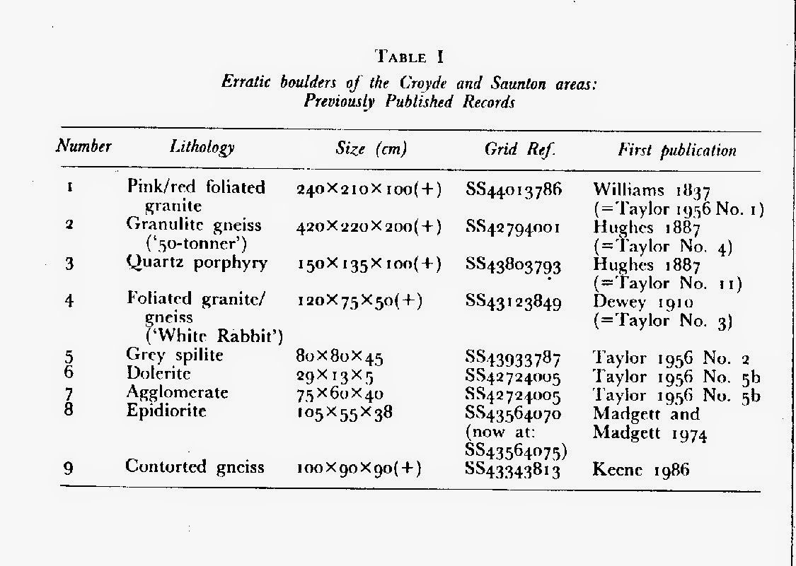
Because this needed recording in the literature, but need putting in the context of other known erratics in the area, I conducted a literature search, and found that very few of the erratic boulders that we knew of were in fact recorded. At the time, though based in London, living at Leighton Buzzard, we had regular family holidays in Croyde - and both son and daughter were "roped in" to help record these boulders - and to find more. In fact they soon turned this into a game with prizes - a stick of Croyde Rock for every "new" erratic boulder with max dimension greater than 50cm (later scaled down to 25cm by my daughter, keen to get as many sticks of rock as possible!) Amazing how rapidly a 9 & 7 yr old become efficient erratic-spotters if the incentive is there!

Family and work commitments delayed publication, but eventually a paper was published in the Transactions of the Devonshire Association, 1987: "A Re-Appraisal of the Erratic Suite of the Saunton and Croyde Areas, North Devon", P A Madgett & E A Inglis; vol.119, pp 135-144.

THIN SECTIONS


At the time of the discovery of the Ramson Cliff boulder I was working with John Catt at Rothamsted, and he encouraged me to have a thin section made, which the Geological Museum staff subsequently identified as an epidiorite, possibly from NW Scotland. In 1974 a short note about this erratic was published in the Quaternary Newsletter No.14. Somewhere I will still have the thin section, and could loan you this, if you are interested in following up the lithology - it would be interesting to know whether it bears any resemblance to any of the Presceli "bluestones"!

During the early 1980s I had several more thin-sections made of the Croyde - Saunton erratics. Peter Keene borrowed some of these, when he had a researcher from North America visiting Oxford Brookes; his comment on the 50-tonner was that while it might well originate from NW Scotland, the lithology also fitted granulite gneiss from Greenland, and speculated that ice-floes could have carried it from there across the Atlantic at a time when the ocean current circulation was different to that of today. That be as it may, there are many and varied far-travelled erratics along this coastline, yet there still seems to be a reluctance among geologists to grant more than grounded ice-flows for their emplacement.

The Lundy glacial evidence (referred to in your blog last week) would support the idea of Baggy - and indeed much of the coastal fringe of N Devon - being over-ridden by an ice-sheet at the same time. I look forward to hearing in a few years time of the results of the investigations hopefully to be carried out by Phil Gibbard's and Tom Spencer's research student...


----------------------

Grateful thanks to Paul for all the above. More to come.....


The Baggy Point area.  The beach to the north is Woolacombe Sands.  The beach to the south is Saunton Sands.  The small one in the middle is Croyde Bay, and the village is Croyde.

In the meantime, here are some key references:

Peter Keene  1989 Read at the Annual Conference of the Ussher Society, January 1989
Classic landforms of the North Devon coast,  Geography Unit, Faculty of Environment, Oxford Polytechnic, Oxford, OX3 0BP.

Keene, P. 1986. Classic Landforms of the North Devon Coast. Geographical Association, Sheffield.

Keene, P. and Cornford, C.  1995.  The Cliffs of Saunton. 9780948444241.  44pp.  £2.95

Kidson, C. 1971. The Quaternary history of the coasts of South West England, with special reference to the Bristol Channel coast. In: Gregory, K.J. and Ravenhill, W. (eds) Exeter Essays in Geography, University of Exeter, 1-22.

Kidson, C. 1977. The coast of South West England. In: Kidson, C. and Tooley, M.J. (eds) The Quaternary History of the Irish sea. Seel House Press, Liverpool.

Kidson, C. and Wood, R. 1974. The Pleistocene stratigraphy of Barnstaple Bay. Proceedings of the Geologists' Association, 85, 223-237.

Madgett, P.A. and Inglis, A.E. 1987. A re-appraisal of the erratic suite of the Saunton and Croyde Areas, North Devon. Transactions of the Devonshire Association, 119, 135-144.

Madgett, P.A. and Madgett, R.A. 1974. A giant erratic on Baggy Point, North Devon. Quaternary Newsletter, 14, 1-2.

Pengelly, W. 1867. The raised beaches in Barnstaple Bay, North Devon. Transactions of the Devonshire Association, 1, 43-56.

Pengelly, J. 1892. The granite boulder on the shore of Barnstaple Bay, North Devon. Transactions of the Devonshire Association, 6, 211-222.

Stephens, N. 1966. Some Pleistocene deposits in North Devon. Biuletyn Peryglacjalny, 15, 103-114.

Stephens, N. 1970. The West Country. In: Lewis, C.A. (ed) The glaciation of Wales and adjoining regions. Longmans, London, 267-314.

Stephens, N. 1974. North Devon. In: Straw, A. (ed) QRA Easter Meeting Field Handbook, Exeter.

Taylor, C.W. 1956. Erratics of the Saunton and Fremington area. Transactions of the Devonshire Association, 88, 52-64.

Taylor, C.W. 1958. Some supplementary notes on Saunton erratics. Transactions of the Devonshire Association, 90, 187-191.