
I was googling about over Russia, as one does, when I came across a most extraordinary pattern of valleys which had to be glacial in origin, with deep anastamosing troughs somewhat like those of the East Greenland Fjords. But unlike the Greenland situation, these troughs are far inland, and can have owed nothing to discharge into tidewater. This is the edge of the Putorana Plateau, in Central Siberia. The plateau is about 500 km x 250 km in extent, with a surface area of c 125,000 sq km. There must have been a big ice sheet here, and the landscapes are truly spectacular:

Ayan Gorge, Putorana
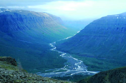
Khikikal River gorge

The basalt plateau and one of the major ice discharge routes
The plateau is a somewhat mysterious place, because there are no roads and no settlements, and if you want to get in or out you have to walk or travel by helicopter from Norilsk, the nearest town. According to the World Heritage site citations, this is essentially a trap (basalt) plateau similar in some ways to the Deccan in India -- but it reminds me a lot of NW Iceland, even down to the shape and arrangement of glacial troughs. In Russia it is also referred to as the Putoransky Reserve. This is the key UNESCO web site:
Within it, there are maps, photos and citation documents. Nowadays, the western part of the plateau is designated as a buffer zone, and the eastern part is heavily protected on nature conservation grounds. On this map we see the World Heritage Site highlighted in green, and the elongated lakes on the western side of the plateau show up clearly, together with their interconnecting valleys.

Russian scientists have discovered that there have been two major glaciations here on the plateau, and this is a map from one of the learned papers:

The Putorana ice sheet is the circular one, more or less in the centre of the map.
Here is another map from the UNESCO document, showing much greater detail on the landscape features:


The plateau surface on the northern, eastern and southern flanks is dissected by rivers flowing is normal dendritic drainage patterns. Very little in the way of glacial modification can be discerned. But the western segment has been dramatically altered by intensive glacial activity, and the dendritic pattern is best described as deranged. The only explanation is that there was heavy precipitation during gacial phases on this western site, with very thick ice and active outlet glaciers flowing westwards. There are overdeepened flooded troughs, and maybe like the lakes of Northern Italy, they are dammed by vast accumulations of moraine. In contrast, the the east the ice must have been thin and frozen to its bed.
Now that's somewhere I would dearly love to visit......... it all needs to be sorted out........
No comments:
Post a Comment