THE BOOK
Some of the ideas discussed in this blog are published in my new book called "The Stonehenge Bluestones" -- available by post and through good bookshops everywhere. Bad bookshops might not have it....
To order, click
HERE

Sunday 30 April 2017

Carn Briw stone collection zone


This is a Bing image (annotated) showing the Carn Briw conical mound on the Carningli ridge, to the west of the Iron Age hillfort.  This small feature -- essentially a pile of stones -- is assumed to be a Bronze Age burial site.  Probably there is -- or was -- a small cist grave in the centre of the mound.

Where did the stones come from?  Well, around the cairn itself there is a heavily pitted ground surface, and it is obvious that the stones used for mound construction have all come from the immediate neighbourhood.  Some of the pits are very well defined, and they are up to 50 cms deep.  On the image above I have drawn a line around the main extraction area.  Hardly anything has come to the mound from more than 30m away.  As ever, economy of effort was the guiding principle.....  and as ever, there appears to have been no selection of stones according to size, colour or rock type.


Foel Drygarn annotated image


This is a close-up image from the fantastic Bing Maps site, showing the key features  referred to in the previous post.

Foel Drygarn Prehistoric "Quarries"


 Bing image of Foeldrygarn, showing the main Bronze Age and Iron Age settlement and fortification features, and the rock outcrops / quarries in the lower (southern) part of the image

 The crags at the western end of the series of rock outcrops

The same view in winter.  This gives an impression of Preseli as it might have appeared over 10,000 years or so of intense periglacial activity after the melting of the Devensian Irish Sea Glacier.  There might have been a small glacier in the cwm beneath the summit of Foelcwmcerwyn during Zone III / Younger Dryas times.  Around 10,000 years ago Ice Age conditions finally gave way to much warmer interglacial or post-glacial conditions much more favourable for human settlement.

If you are into Neolithic / Bronze Age quarries, and want to see a real one for a change (instead of the fantasy quarries at Rhosyfelin, Carn Meini and Carn Goedog), go to have a look at Foeldrygarn, at the eastern end of the Mynydd Preseli upland ridge.   Here we can see some real evidence of extensive "quarrying"or stone gathering activities.  It's interesting that the quarries are not mentioned on the otherwise excellent Coflein description of the site written by Toby Driver.   This is reproduced below.

First, the site geology.  It's very complex indeed, with at least three different igneous rock types in close proximity.  Probably it was once a volcano or maybe the core of a volcanic complex, but not all of the rocks are "deep" rocks intruded and cooled far beneath the earth's surface-- some of them appear to be volcanic ashes and lavas laid down from surface eruptions.  There were probably many phases or eruptions, some of them very violent or explosive, revealing and then burying materials of different ages.  I wouldn't like to be a geologist trying to work it all out.  Maybe Rob or somebody else can enlighten us -- since there is not much that I can find in the literature.  Actually rock lithology is not that important here -- no particular rock type seems to have been preferred over any other by the quarrymen.  For the record, I think there are dolerites (none of them spotted, as far as I can see), rhyolites, lavas and ashes all exposed within a very small area.

This is the description from the Geology of Britain viewer:

Unnamed Igneous Intrusion, Ordovician - Microgabbro. Igneous Bedrock formed approximately 444 to 488 million years ago in the Ordovician Period. Local environment previously dominated by intrusions of silica-poor magma.

Setting: intrusions of silica-poor magma. These rocks were formed from silica-poor magma intruded into the Earth's crust. It cooled to form intrusions ranging from large, coarse-crystalline, often gabbroic, plutons at depth to smaller, fine to medium crystalline, often basaltic dykes and sills.

Fishguard Volcanic Group - Tuff And Lava. Igneous Bedrock formed approximately 464 to 467 million years ago in the Ordovician Period. Local environment previously dominated by explosive eruptions of magma.

Setting: explosive eruptions of magma. These rocks were formed from viscous and highly gaseous magma. It rose to the surface, where sudden pressure relief caused explosive volcanic eruptions, producing fragmentary pyroclastic material or ash.

The key man-made features here are the three massive Bronze Age burial cairns that give the hill summit its name, and the embanked enclosures and hut sites of the Iron Age hilltop village.  There are several features that have made this site attractive: (1) it's an isolated hill with panoramic views in all directions -- valuable from a strategic or defensive point of view; (2) there is a broad summit plateau which is not by any means flat but which was not so steeply sloping as to discourage settlement; (3) there is an abundant stone supply from the summit crags and the accumulated scree on the southern and south-western flanks of the summit.  I suspect that this latter factor was of vast importance -- especially for the tribal groups who decided to build those three massive burial cairns.

Yesterday I led a group of walkers around the eastern part of Mynydd Preseli -- very cold and windy.....!  Here are some of my photos:


Foel Drygarn from the south, showing the outcropping igneous rocks in the crags to the left of the summit. If you zoom in you can see the clear "quarrying platform" beneath the crags from which hundreds of tonnes of stone have been taken --almost all of it from accumulated scree banks of frost-shattered material.


 A close-up of some of the crags.  Between the grassy banks and the rock face there is a back-slope in places, indicative of stone removal on a substantial scale. I need more time to examine the micro-morphology of the site.......

On the left, the edge of one of the cairns, with a dolerite rock collection site immediately adjacent.  They did not need to go far for their rocks........


Some of the walkers scrambling over one of the cairns.  Look at the stone sizes -- there is no stone here which is heavier than c 40 kg, ie capable of being carried by two men with a stretcher......


 Close-up of the flank of one of the cairns.  The great majority of these stones can be carried by one man, woman or older child without too much difficulty.  Nonetheless, there are many thousands of stones in the three cairns, indicative of substantial community commitment and effort.

 So -- the lessons arising from all of this?  Yes, Bronze Age people did "quarry" or collect stone on a substantial scale in this area, but the guiding principle always was economy of effort, and the easy availability of stone in convenient-sized blocks on the hill summit of Foel Frygarn may well be the explanation for (a) the choice of the hill as a burial site, and (b) the extraordinary size of the cairns themselves.

I see no signs here that there was any preference for a particular rock type over any other, or that there was any physical breaking away of lumps of stone from the exposed rock faces.  I think that no tools were used.  All of the stones have been taken from pre-existing banks of scree or slope deposits, made of accumulated masses of frost-shattered material.  By and large, the edges of the stones in the cairns themselves are sub-angular rather than angular.  If the stones had been taken from "the living rock" by quarrymen with tools, the edges of the stones would certainly be very sharp.

As far as I can see, no big blocks (the sort of things used in megalithic stone settings or cromlechs) have been taken from here.

As I have said before, maybe the term "collecting"or "gathering" should be used in preference to the term "quarrying".......

=====================

My description of the site:

Foel Drygarn (158336 )

This prominent hill mass towards the eastern end of the Preseli upland ridge stands in glorious isolation, and the summit can only be reached via a stiff climb from the nearly "Golden Road" footpath.  The name means "the bare hill with three cairns" -- and the three massive Bronze Age burial mounds on the summit are the most spectacular features of this age in Pembrokeshire.  They lie within the confines of an Iron Age hillfort which contained both an animal enclosure and a substantial settlement site.  Scores of hut circles can still be made out in the turf.  The defensive ramparts are prominent.  A gorgeous location, with spectacular views in all directions.  Maybe we shouldn't classify this as a "Preseli tor" but on balance I have included it in this list because there are indeed spectacular crags here towards the western end of the summit.  The rocks are rhyolites rather than spotted dolerites, and as with the other high tors the dominant process which has shaped the crags in recent millennia is frost shattering and the downslope movement of detached blocks under the influence of gravity.  The jury is still out on whether the summit of Foel Drygarn was affected by glacier ice during the last glaciation.


================   

http://www.coflein.gov.uk/en/site/94948/details/foeltrigarnmoel-trigarnfoel-drygarn-hillfort


Coflein Site Description

Frequently photographed and one of the most dramatically sited and visually striking Iron Age hillforts in Wales, Foel Trigarn occupies the easternmost ridge on Mynydd Preseli, its characteristic silhouette dominating much of the east Pembrokeshire skyline. Three main enclosures can be traced, defined by stone walls or stone-revetted banks, with traces of a ditch around the inner rampart. The earliest was probably that on the very summit, an oval fort set against natural cliffs on its southern side, enclosing 1.2 hectares and with main gates on the east, west and south sides. Attached to this first enclosure, and probably representing later periods of expansion, are a second enclosure on the north and east side which mirrors the outer ramparts of the first, and a third outer annex to the east. The most striking characteristic of Foel Trigarn is its pock-marked interior, the sites of at least 227 levelled house platforms where Iron Age houses once stood. There are also fainter traces of a further 42 uncertain platforms bringing the total closer to 270 house sites. It is highly unlikely that all these house sites were occupied at the same time. The entire hillfort was probably occupied and expanded over many centuries, rather than being used by a single leader or group of people. We are effectively seeing the remains of a complex and long-lasting prehistoric village, with all its phases of occupation on show. Early excavations in 1899 by S Baring Gould unearthed Iron Age and Roman pottery and artefacts which included spindle-whorls, fine glass beads and a jet ring from some of the house platforms. Sling stones were also found in ‘…great numbers…some in piles..’ (Baring Gould et. al., 1900, 210). A new survey by the Royal Commission and researchers from Portsmouth Polytechnic (in 1988) provided the first detailed plan.

On the summit stand three massive stone cairns after which the hill is named. These are interpreted as Bronze Age burial cairns, massive communal monuments covering the bones, or ashes, of one or several special individuals. Similar examples of pre-existing cairns surviving within later stone forts can be seen at Carn Goch in Carmarthenshire, Pen Dinas, Aberystwyth in Ceredigion and at Tre’r Ceiri on the Llyn Peninsula, Gwynedd. As these cairns were never plundered for their stone, despite being surrounded by hundreds of houses, we must conclude that the occupants venerated their distant ancestors, while at the same time deriving power and social status from the acquisition of such a prominent, and sacred, hilltop.

The size and complexity of Foel Trigarn, one of the largest north Pembrokeshire hillforts along with Carn-ingli, Garn Fawr and St David’s Head, suggests a role and function distinct from the numerous smaller hillforts like Castell Henllys. It is likely that this was a significant centre of population in its time, its design and construction initiated and overseen by a powerful regional leader. If, as one interpretation of the place mentioned by Ptolemy indicates, the Octapitai tribe occupied St David’s Head, perhaps a similar group whose name was never recorded by the Romans sited their ‘tribal capital’ here, commanding the Iron Age lands hereabouts.

Sources: Baring-Gould and others in Archaeological Cambrensis 5th series 17 (1900), 189-211

T. Driver, RCAHMW, 21 September 2009

===================

 This is probably how the heavier stones were carried for a maximum distance of c 60m

Monday 24 April 2017

Land of Legends -- what the Rhosyfelin entry should have said


As I have reported, Bronwen Price of Literature Wales has refused to alter the highly misleading and inaccurate text of the published web site entry on Craig Rhosyfelin.  A pity, since that would have involved no more than a minute's work.  This is what the entry should have said, and I offer it, without charge, to Literature Wales in a spirit of good will:

Craig Rhos-y-felin, Crosswell

    • Region : South West Wales
    • Grid Ref : SN 11650 36140
    • Google Map
    • Add to your list


This is a very beautiful site, with a rocky gorse-capped crag set in a deep river valley near a ford -- a perfect place for a picnic.  It looks peaceful enough, but it is the scene of an animated dispute between academic disciplines about its links with Stonehenge.  It all started some years ago when geologists identified some of the rock fragments in the soil at Stonehenge as having come from the Rhosyfelin area.  Archaeologists then moved in, and over several digging seasons they claimed to have discovered a Neolithic quarry used for the extraction of bluestone monoliths destined for Stonehenge. In two learned papers, earth scientists disagreed, and claimed that all of the “quarrying” features were entirely natural.  Further, they argued that the bluestone debris on Salisbury Plain had been carried there by the great Irish Sea Glacier which flowed across Pembrokeshire and up the Bristol Channel around half a million years ago.  So is there really a Neolithic quarry here, or is that simply a modern myth?  Only time will tell…….


-----------------------


I think that the suggested entry is accurate and balanced, and should not upset anybody!  The existing entry on the web site is this:

Some of the bluestones of Stonehenge were quarried here. First used for a local monument in about 3400 BC, they were moved to Salisbury Plain 500 years later where they stood in various settings before the giant inverted ‘U-shaped’ stones joined them in 2500 BC. This makes Stonehenge a truly Welsh site - something supported by the Boscombe Bowmen: seven individuals re-buried in a mass grave near Stonehenge around 2300 BC. All were  seemingly born and raised in south-west Wales, travelling to Wessex during their lifetime. This connection and journeys from the west are recalled in folk legend - Geoffrey of Monmouth (c. 1100-1155) retells the ancient belief that Merlin brought Stonehenge from Ireland. The rock face retains the natural pillar formations which the stone-cutters exploited. You can enjoy a picnic where they camped 5400 years ago.

SOURCE:
http://www.landoflegends.wales/theme/sacred-and-spiritual

Stonehenge video rolls on......


Much to my surprise, there have now been more than 91,000 views of my video on YouTube.  It's been around for a few years now, and of course attracts comments galore from the lunatic fringe,  but every now and then somebody says something sensible.  Anyway, here it is in case any of our modern blog followers are not aware of it.  Nothing has come along, in the period since it was made, to change any of my views......

Saturday 22 April 2017

Fantasies versus science


From the BBC coverage of today's March for Science. 

A gentle reminder for certain archaeologists who ignore evidence (and ignore inconvenient peer-reviewed papers) and who subvert and degrade science by dressing up their own assumptions, speculations and fantasies as "facts" -- for reasons that are sometimes rather too obvious.  Headlines, notoriety, and a good flow of research funds are all very desirable things.......

A gentle reminder too for local authorities, tourism bodies and government agencies (you know their names) who are so obsessed with the need to market places like West Wales as possessing more "heritage icons" than anywhere else that they systematically ignore serious scientific findings and prefer to dress up recently-manufactured myths (such as the quarrying of bluestones at Rhosyfelin and Carn Goedog) as "established facts".   Commercial interests, as I have said before, have overturned respect for the truth -- and nobody seems to mind.

Shame on all of them, for hastening the demise of science and encouraging pseudo-science and "alternative facts."  I, for one, am with the thousands of scientists who marched in many of the great cities of the world today.  Keep waving those placards, boys and girls!

Work at Trellyffaint cromlech


Thanks to George Nash for inviting me to come over and have a look at the work currently under way at Trellyffaint cromlech, not far from Moylgrove.  A fabulous spring day, and a very interesting chat.

The cromlech is reputed to be a ruined portal dolmen, and indeed it is in a bit of a decrepit state.  Did it collapse during construction, or after it was abandoned?  It's built of natural erratics presumably collected from the neighbourhood.  The big supporting rock on the left is made of dolerite, but I think the capstone and the right-hand support are made of volcanic ash, as are several of the smaller stones.  There are other small dolerite cobbles lying around, and some that seem to be made of rhyolite and local shales and mudstones, some of which are metamorphosed.  There are lumps of quartz lying around too; these have probably come from bands of quartz in the mudstones exposed in the nearby cliffs.

Was there a mound partly covering the burial site?  George thinks that this is very likely.

There may have been another cromlech just to the left of the one seen in the photo -- so was this related in some way to the "cromlech cluster" at Cerrig y Gof?

The main work of George's research team has concentrated on the cupmarks on the capstone and other stones, and on ground surveys.  There is no actual excavation at the site this year.  Some interesting things are emerging.  George will no doubt report on these when he is ready.......

Friday 21 April 2017

Literature Wales: the truth is whatever you want it to be

 Prof MPP directing the dig at Rhosyfelin.  Now the myth manufacturing machine rolls on, thanks to a shove from Literature Wales, which should stick to books

Some days ago I complained about this extraordinary item on the new Literature Wales website called "Land of Legends":


Craig Rhos-y-felin, Crosswell

    • Region : South West Wales
    • Grid Ref : SN 11650 36140
    • Google Map
    • Add to your list
 

Some of the bluestones of Stonehenge were quarried here. First used for a local monument in about 3400 BC, they were moved to Salisbury Plain 500 years later where they stood in various settings before the giant inverted ‘U-shaped’ stones joined them in 2500 BC. This makes Stonehenge a truly Welsh site - something supported by the Boscombe Bowmen: seven individuals re-buried in a mass grave near Stonehenge around 2300 BC. All were  seemingly born and raised in south-west Wales, travelling to Wessex during their lifetime. This connection and journeys from the west are recalled in folk legend - Geoffrey of Monmouth (c. 1100-1155) retells the ancient belief that Merlin brought Stonehenge from Ireland. The rock face retains the natural pillar formations which the stone-cutters exploited. You can enjoy a picnic where they camped 5400 years ago.

SOURCE:
http://www.landoflegends.wales/theme/sacred-and-spiritual

As I pointed out, the only thing that is demonstrably correct about all of that is that Rhosyfelin is a pleasant picnic site.

Anyway, I wrote to both Cadw and Literature Wales about it, pointing out that while most of the entries on the web site were entertaining and factually accurate, this one was not.  In fact, it was so inaccurate and misleading that it was likely to harm the reputation of Literature Wales and its sponsors Visit Wales and the Welsh Government.  Further, it broke with public sector etiquette by (a) dressing up speculations and assumptions as facts; and (b) seeking to create a new myth rather than reporting upon an old one.

It response to my request that the item should be removed because of its inaccuracy, or at the very least rewritten so that it presented the situation in a more nuanced way, I got a thoroughly bizarre response from Dr Bronwen Price of Literature Wales (who apparently has a 2009 Cardiff PhD in archaeology, specialising in the Late Neolithic and Early Bronze Age of the Irish Sea region).  She admitted that she had written the text herself.  She seemed to think that because Rhosyfelin has been studied by Mike Parker Pearson and that because his results have been published in "Antiquity",  he is probably correct about everything.  To cut a long story short, she refused to change a single word, and stated that she would not enter into any more correspondence on editorial matters relating to the new web site.

So there we are then.  Bronwen's truth is what we are stuck with, and to hell with the facts.

Does any of this actually matter?  Well, if you are a tourist visiting Wales, probably not.  But if you are a scientist concerned about the ongoing degradation of scientific integrity, it does indeed matter.

The 1607 tsunami in the Bristol Channel


The TV prog last night about the 1607 tsunami was quite well done -- but it was really a 30 minute programme stretched out interminably, presumably on the basis that the director, having made lots of spectacular clips of drowning peasants, smashed-up buildings,  dead cows and giant waves,  could not resist getting his money's worth by showing all of them at least a dozen times.

Anyway, that wasn't Prof Simon Haslett's fault,  and the info presented was really quite convincing -- through documentary sources, historical evidence of peak water levels, coastal stratigraphy and oceanographic modelling.  The evidence is compelling that this was really a tsunami and not just a storm surge coinciding with an exceptionally high tide.  I liked the way that Simon Haslett and his colleague worked through the evidence systematically and drew perfectly reasonable conclusions from it.

This is not new news, and I think I might even have seen this programme before -- or at least parts of it........

Today I checked with Simon, and he confirmed that shells collected from the sand layer (the tsunami layer) in coastal exposures were too young for reliable C14 dating -- as I had anticipated.  Shells and other materials only 400 years old are rather difficult to date accurately.

I'm not entirely convinced by the argument that the big blocks on the beach were all aligned by the force of incoming water, and I'd like to have a look at them........  And I'm not at all convinced that the rock platforms shown were cut by the tsunami -- to me they looked just like all the other raised beach platforms that are scattered around the coasts of SW Britain.

But those are minor points.

PS -- yes, I have seen it before!  I see now that this was first broadcast as a Timewatch documentary in 2005.

Thursday 20 April 2017

LIDAR imagery coming along


Thanks to Andy for drawing attention to this -- it's not a work of art, or an experimental mapping exercise, or even a map of Britain made up of scraps of waste paper stuck onto a board --  but it is in fact the database showing LIDAR coverage of England and Wales.  When this is complete, you will be able to zoom in and pick up incredible details on small segments of the land surface.  I'm not sure what the overall accuracy is, but generally surface altitudes will be accurate to within 25 cms.

Wednesday 19 April 2017

Penanty-isaf gallery grave site


Another satellite image from Apple Maps -- this time showing the Penanty-isaf gallery grave, just to the south of the two prominent hawthorn trees and to the east of the farm which gives the site its name.

Grid ref:  SN 09560 33896.  Straight out onto the common from the farm called Pennant-isaf or Penanty-isaf (depending on which map you are looking at....)

Banc Llwydlos prehistoric burial sites


I have just upgraded some of the software on my computer, and suddenly have access to Apple Maps -- and a new satellite coverage with amazing definition.  Here are the two features on Banc Llwydlos to which I have devoted some attention recently.

The gallery grave stone alignments are perfectly obvious.  The cromlech and rough hollow which we can refer to as an embanked grave or a chambered tomb is at the eastern edge of the bouldery area right of centre on the image.

Friday 14 April 2017

More Rhosyfelin gobbledeygook............


 This is the title of the video -- pretty cheeky, if you ask me, since this extraordinary nonsense could bring my own book -- of the same name -- into disrepute among serious seekers after the truth..... should I complain about copyright infringement?

A few weeks ago I spotted this extended piece of pseudo-science from Hugh Newman, on YouTube and on a web site called "Megalithomania", which I chose to ignore on the basis that it falls fairly and squarely into the trash bin reserved for the lunatic fringe.  This is the sort of material that causes even quite senior archaeologists to roll their eyes and move on rapidly to something else --- since it does the reputation of archaeology no good at all.

http://www.megalithomania.co.uk/index.php  

https://www.youtube.com/watch?v=27uYbTNwIe8

Anyway, you could have knocked me over with a feather this very morning when I discovered that the video has now been accorded official recognition and embedded in the "Land of Legends" web site:

http://www.landoflegends.wales/location/craig-rhos-y-felin-crosswell#

There is certainly a strange sort of fascination in watching this video!  Try it for yourself, and wonder at the garbled rubbish that can come from people who have a vague understanding of what is what, and who have neither the time nor the inclination to do any proper research on the things they are talking about.

But what was the point of putting this on an official web site published by Literature Wales and funded via the public purse?  Was this intended to give potential visitors to Wales a good belly laugh, to relieve the boredom of their everyday humdrum lives?  Let's assume that this is just Literature Wales poking fun at the people who take this sort of stuff seriously.........

That having been said, what was the point of including Rhosyfelin on the new web site as a place of "sacred and spiritual significance" when there is nothing remotely sacred or spiritual about it?  Aren't there enough sites in Wales that really do have associations with saints, pilgrims, hermits and religious beliefs?

Wednesday 12 April 2017

The sanctification of Craig Rhosyfelin


There is a lot of discussion just now about false news and "alternative facts" .......  and here we go again.

I have been quite involved recently in the local promotion of the "Year of Legends" in Wales.   With the support of the Welsh Government, Visit Wales and the local authorities,  a massive amount of marketing money has been thrown at this -- and some very fine material has appeared, with the object of attracting more visitors to Wales.  Just type in "Wales Year of Legends" into Google, and see what appears........

http://www.visitwales.com/legends

https://businesswales.gov.wales/zones/tourism/YoL2017

https://www.celticos.com/year-legends-wales 

http://www.visitpembrokeshire.com/explore-pembrokeshire/pembrokeshire-myths-legends/

Obviously, when it comes to fairy tales, myths and legends, one does not want to get too heavily involved in investigating what is truth and what may be fiction -- but we do start to get into trouble when myth is presented as fact by people who should know better.

Here is the latest example, in a very lavish web site which has just gone live, under the auspices of Literature Wales -- with considerable public funding from Visit Wales.  As we have stated on this blog many times before, Craig Rhosyfelin is now hot property, busily promoted by the National Park and Pembrokeshire CC on the basis that "our heritage is better than the heritage of other parts of Wales".  I have pointed out to the powers that be, on many occasions, that they need to be very careful about the presentation of myths and wild hypotheses as "facts" -- but they are not inclined to listen to me.  Who cares about science and evidence, when all that matters is a good story?  More to the point, who cares about the truth, when we need to pull more tourists into the county to help the local economy?  So marketing is all that matters.  Anyway, as I was saying, here is the latest example:

Craig Rhos-y-felin, Crosswell

    • Region : South West Wales
    • Grid Ref : SN 11650 36140
    • Google Map
    • Add to your list
Some of the bluestones of Stonehenge were quarried here. First used for a local monument in about 3400 BC, they were moved to Salisbury Plain 500 years later where they stood in various settings before the giant inverted ‘U-shaped’ stones joined them in 2500 BC. This makes Stonehenge a truly Welsh site - something supported by the Boscombe Bowmen: seven individuals re-buried in a mass grave near Stonehenge around 2300 BC. All were  seemingly born and raised in south-west Wales, travelling to Wessex during their lifetime. This connection and journeys from the west are recalled in folk legend - Geoffrey of Monmouth (c. 1100-1155) retells the ancient belief that Merlin brought Stonehenge from Ireland. The rock face retains the natural pillar formations which the stone-cutters exploited. You can enjoy a picnic where they camped 5400 years ago.
SOURCE:
http://www.landoflegends.wales/theme/sacred-and-spiritual

Now this purports to be an accurate statement of what Craig Rhosyfelin is all about.  The trouble is that almost every sentence is full of "alternative facts." In other words, nonsense.  There is no evidence that any of the Stonehenge bluestones were quarried at Rhosyfelin -- all we know is that some of the rock fragments at Stonehenge came from the Rhosyfelin area.  We do not know that any of the stones were used in a local monument before being shifted to Salisbury Plain.  Giant inverted U-shaped stones?!!    The seven Boscombe Bowmen came from SW Wales?  I know of no evidence in support of that contention.  Geoffrey of Monmouth?  Here we go again.......  Natural pillar formations which the stone cutters exploited?  Zero evidence of that happening.  Lots of people have camped there over the millennia -- that's about the only bit of the paragraph that seems more or less reliable.

For years we have had the HH Thomas / Atkinson myth promoted for commercial reasons in spite of the fact that there is no evidence in support of it;  and now the MPP version has entered the mythology lexicon.   Should one laugh, or weep?


Tuesday 11 April 2017

National Park "challenge" on the Stonehenge story

Some months ago the National Park asked Geooff Wainwright and myself to provide short summaries of our ideas relating to the origins and transport of the bluestones.  Sadly, Geoff died before this appeared in print.   But here is a copy of our mini-debate, on page 39 of the free "Coast to Coast" newspaper which is distributed to holidaymakers in Pembrokeshire.


If you have difficulty in reading the text, click to enlarge.

Banc Llwydlos and Occam's Razor


Tycanol Wood -- gnarled trees, mossy stones and a fortified Iron Age site nearby.  One of many settlement sites to the north of Mynydd Preseli


Prof MPP is booked in to do another talk for the National Park at Castell Henllys on 20th September -- it's now become an annual event!  Like the arrival of the first cuckoo of spring, the archaeologists turn up in N Pembs every year, in late summer, looking for the holy grail.  So it looks pretty certain that they will be hoofing about this year too, in the first three weeks of September.  The betting is that they will be looking, once again, for "proto-Stonehenge", and that the hunt will be concentrated to the north of the Preseli upland ridge.  Banc Llwydlos might well be on the cards.........

On Wed 20th Sept there will be daytime event (10 am - 3 pm) entitled "Prehistoric Preseli Tour / Bluestone event" and in the evening Prof MPP will talk (again) on the Welsh origins of Stonehenge.

The working hypothesis (should that be "ruling hypothesis"?) is that there was a bluestone circle somewhere in the area that was systematically dismantled and carted off to Stonehenge as some sort of demonstration of political unification.  The bluestones, highly valued and maybe thought to embody the spirits of the ancestors, were not stolen or collected by the tribes of Wessex, but were taken as a goodwill gesture by the rather sophisticated tribes of North Pembrokeshire.  There was powerful political and spiritual symbolism in the stones themselves, and the act of giving them up and transporting them all the way to Stonehenge was designed to impress the recipients and to achieve some sort of political unification.

This theory is elaborated over and again, with minor tweaks  -- and we will hear the latest version on 20th September, along with a report on the latest incredibly exciting discoveries..........

Readers of this blog will not be surprised to hear that I am completely unimpressed by all of this and that I consider it to be entirely unsupported by evidence of any kind.   Having recently taken a good look around the terrain between Carn Goedog and Tafarn y Bwlch (including Brynberian Moor and Banc Llwydlos) I'm impressed by what appears to be a long history of settlement in the area and with the abundant traces of settlement from the Neolithic to the Middle Ages -- but there is NOTHING to suggest any special reverence for spotted dolerite or foliated rhyolite, and NOTHING to link the area archaeologically with Stonehenge.

 To repeat some points made a few months ago:

1.  There is no hard evidence in the area of  any particular stone type being valued, or being accorded veneration, over and above any other stone type in prehistoric Pembrokeshire.  Stones of all lithologies, shapes and sizes were used wherever it was handy to use them. (That, by the way, is exactly the case at Stonehenge as well.)  If more spotted dolerite pillars and slabs appear to have been used in north Pembrokeshire, it is because there were simply more of them lying around as glacial erratics.

2.  There is no hard evidence, as far as I know, of any large stone in a Pembrokeshire monolithic setting being transported more than a few metres from its place of origin to its place of use.

3.  Because of the abundance of glacial erratics littered across the landscape, there was no need for any quarrying of stone from "bluestone quarries."  So there are no bluestone quarries, and the obsession with searching for them and "finding" them them is nothing more than a rather charming fantasy.

4.   Although I am a geographer who quite enjoys looking for patterns and arrangements in the landscape, I can see no "siting preferences" with respect to monolithic /  megalithic settings based on proximity to springs, views of the mountains or the sea, alignments, transition zones between boggy and and rocky land, or anything else.  The only thing I would concede is that some fortified sites and burial sites are located on hill summits.

5. A thorough examination of the field reports of the Dyfed Archaeology staff suggests  that the cultural associations in Mesolithic, Neolithic and early Bronze Age times were predominantly with other parts of the "Atlantic Fringe" and NOT with Salisbury Plain and the Stonehenge area.  There does not seem to be any cultural context for a situation in which people would suddenly want to start gathering up 80 bluestones and carting them off to Stonehenge.

6.  The prehistoric inhabitants of north Pembrokeshire were a pretty pragmatic bunch.  They clearly had their reasons for making "statements" in stone, but they were also driven by utilitarian principles, and always used whichever handy stones were fit for purpose.  They may have been simple folk, but they were smart enough to know about cost / benefit analysis.

If we look at the prehistoric traces that litter the landscape to the north of the Preseli ridge, the most parsimonious explanation of them is that there were local tribes here which shared many building techniques and maybe cultural / religious beliefs with other tribes in western Britain and Ireland but which had no interest in gigantic civil engineering projects or grand political gestures.

Strange that the archaeologists are so reluctant to take on board these relatively simple points and that they are apparently still hell-bent on perpetrating their modern myth, in spite of failing to come up with any evidence of quarrying or long-distance stone transport.

Sunday 9 April 2017

Holocene sea-level rise around the British Isles


Somebody put this map on Facebook -- a nice illustration of the post-glacial eustatic rise in sea level around the shores of the British Isles.

Saturday 8 April 2017

Banc Llwydlos cromlech (3)


The Dyfed Archaeology fieldworkers have expressed the view that this small feature at Banc Llwydlos (PRN 100702) is simply a "small sub-circular enclosure'' or "stone built structure" -- they do not define it as a burial site. This is intriguing, since the feature has quite close parallels elsewhere....

See this, on Scillonian entrance graves:

Scillonian entrance grave

From Wikipedia, the free encyclopedia

The entrance graves of Cornwall and the Isles of Scilly, and south east Ireland are megalithic chamber tombs of the Neolithic and early Bronze Age in the British Isles. Comparable sites are also known in Brittany and the Channel Islands. They are generally known as the Scillonian group as the greatest concentration of the tombs is found on the Isles of Scilly.

Examples include Bant's Carn and the Innisidgen and Porth Hellick Down tombs, all on St Mary's.

They consist of a narrow entrance which leads into a rectangular burial chamber covered by a small round stone cairn usually revetted with a kerb. In some examples a sill stone blocks the entrance. The walls of the chamber themselves are of either orthostat slabs or stone courses, covered with several large capstones. Both the cairn and the chamber often exploit natural stone outcrops or boulders in their construction.

Entrance orientations in Scillonian graves follow no discernible pattern and they appear to have been used for deposition of multiple cremation and inhumation burials with up to 60 individuals found at Knackyboy Cairn on the island of St Martin's. Occupation debris has also been found in the graves which implies that they were actively used sites possibly for wider ritual purposes and/or as territorial markers.

The small size and simplicity of these monuments compared with the more complex tombs being built elsewhere in Britain imply that the areas where they are found preserved older methods of burial. The earliest known finds from Scillonian entrance graves include fragments of middle Neolithic Carn Brea type ware and have led some archaeologists such as Paul Ashbee to argue that they are in fact of early Neolithic or even Mesolithic date. Much of the Bronze Age material excavated from entrance graves is considered to be related to later re-use.

==========

The island of St. Martins is home to one of the most populated tombs in British prehistory, containing the remains of up to sixty people. During the Early Bronze Age people were buried in entrance graves: roughly circular structures made of stones and soil that overlay a rectangular-shaped chamber and were surrounded by a kerb of boulders. It was possible to enter the chamber from outside and people were placed in these tombs over a period of years. Tombs of this type are confined to the Isles of Scilly and a small area of the mainland in West Penwith, Cornwall, Tramore, Ireland and small numbers of similar monuments are known in the Channel Islands and Brittany.


==================

Here are the traces of two of these entrance graves, the first on Gugh Island and the other on Tresco:


Here is another example of a propped slab or earthfast cromlech -- this is from St David's Head.


In the case of Banc Llwydlos, the prop is not so spectacular, and is indeed rather crude, but there is no doubt that the "capstone" is propped up, and Murphy and Wilson suggest that it is supported at both ends.  That is not the sort of thing you find in hut circles or animal enclosures  -- so the general drift has to be in the direction of a burial site.  Simple tombs of this type are sometimes referred to as "sub-megalithic", and evidence suggests that they may be late Neolithic or early Bronze Age features.  This means they are intermediate between the very spectacular and technically advanced "portal dolmens"and the much simpler cist graves that became popular in the Bronze Age.  At the same time long barrows were giving way to smaller round barrows with smaller chambers or stone-lined "boxes" inside them.

Finally, there are abundant unimposing ruined "chamber tombs" all over west Wales.  In Pembrokeshire, the best known are at Carn Besi, Parc-y-llyn (Ambleston), Marros, Manorbier,  Angle (Devils' Quoit), Eithbed, St Elvis, Carnllidi, Garn Wnda, and Garn Wen, Goodwick (three crude chambered tombs in a "cemetery").

 Two of the simple chambered tombs at Garn Wen.  Each of the three (or four) tombs here is assumed to have been covered by a low mound of earth and stones.

In some of these, the burials appear to have taken place in a very small chamber beneath the capstone.  In others, the chamber extended behind the capstone, possibly roofed over with other stone slabs which have subsequently broken or collapsed or been taken away for other uses.  In some illustrations, there are suggestions that wooden beams or tree trunks were used, which have by now of course rotted away completely -- this might explain why, in some situations (such as Banc Llwydlos), there is a hollow bounded by raised embankments.

I'm struck with the similarity with the small "entrance grave" tombs of Cornwall and the Isles of Scilly -- but I suppose that until this site is excavated,  my guess is no better than anybody else's.


Banc Llwydlos cromlech (2)


 Illustrations from the Dyfed Archaeology Report (on the plan N is at the top).  The big "balanced" slab is the one to the SE, surrounded by a cluster of smaller stones.

From the Dyfed Archaeology record -- the site (which I initially thought to be unrecorded) is in fact mentioned by Murphy and Wilson 2012, and is given the reference number PRN 100702.

Here is the description:

500 metres (that's a mistake -- it should be 50m) to the east of PRN 100700 lies a small sub-circular enclosure measuring approximately 7.0m in diameter (PRN 100702). It is of unusual construction, being made of very large stone blocks, some of which are set within an earthen bank. Incorporated within the eastern side of the circle is a large stone slab lying in a horizontal position, that has been levelled by balancing it on several smaller stones placed underneath it (see photo below). The stone slab is 2.6m long and 2.0m wide at its widest point. This site had never been recorded before, not even during the field survey in 1984 undertaken by Pete Drewett that recorded sites in close vicinity to it such as PRN 100700.

-----------------

The area of Banc Llwydlos has been little studied in the past but this fieldwork in 2011 and the field visits undertaken in 2009/10, also as part of the scheduling enhancement programme, have shown the high quality and rarity of prehistoric sites in this area. 500m to the east of the two sites described above lies an already scheduled hut circle group (PRN 1565, SAM PE370) and 300m to the southeast lies another hut circle and enclosure group recorded in 2009 (PRN 14373) that is of equal importance.

More Banc Llwydlos records

Here are some more records from the excellent Dyfed Archaeology Report No 2012/6 by Murphy and Wilson.  I'm very happy to help to publicise this work, since it seems to me to be brief, accurate and mercifully free of unnecessary speculation.

Not all of the features are shown on the map.  But there does seem to be an extraordinary concentration of features here -- it's a very good site for settlement and all sorts of other activities, beneath the steep slope of Banc Llwydlos, dry and sunny, and sheltered from the prevailing westerly winds.  There appears to be a very long settlement history, running from neolithic into Bronze Age and even into the medieval period.


DYFED ARCHAEOLOGICAL TRUST
REPORT NO. 2012/6 PROJECT RECORD NO. 100689
January 2012
SCHEDULING ENHANCEMENT PROJECT 2011: PREHISTORIC SITES FIELDWORK
– PEMBROKESHIRE ADDITIONAL SITES

Fran Murphy & Hubert Wilson

www.dyfedarchaeology.org.uk/projects/schedulepembroke2011.pdf

PRN 1565 NAME BANC LLWYDLOS TYPE UNENCLOSED SETTLEMENT PERIOD Bronze Age? NGR SN09303311 CONDITION Damaged STATUS SAM-PE370 FORM Earthwork

SUMMARY An oval enclosure within which are the remains of several circular huts. To the SW of the enclosure are the remains of a rectangular hut.

LONG DESCRIPTION An oval enclosure c.20m in diameter within which are the remains of several circular huts. To the SW of the enclosure are the remains of a rectangular hut. This unenclosed settlement is located near a stream on a gentle NE facing slope of Banc Llwydlos at 240m above sea level. The features are visible as low stony banks. Probably prehistoric in origin but difficult to date, although its position close to a stream may indicate a later date - see nearby unenclosed settlement features PRN 14373 & 1579. FM 2011

===============================

PRN 1579 NAME BANC LLWYDLOS TYPE ENCLOSURE GROUP PERIOD Medieval/Post Medieval? NGR SN09073339 CONDITION Damaged STATUS FORM Earthwork

SUMMARY Circular enclosure and associated rectangular hut.

LONG DESCRIPTION Visited in April 2011. As previously described. The enclosure is situated on the west bank of a stream on the NE facing slopes of Banc Llwydlos at 230m above sea level. See OS card for detailed description. FM May 2011
Bracken has infested the area. There are hints of stone wall bases, but it was difficult to assess the true form and extent of the feature. Its streamside location, on a dry terrace, suggests that a long hut or fold may well be placed here. There was also noted, the line of a sub-circular boundary bank or wall, defined simply by a line of small boulders, enclosing an area c.15m in diameter or 15m by 15m. Its precise form is uncertain. . RPS October 2002
Possibly a denuded long hut site. RPS August 2001.

======================


PRN 100699 TYPE HUT CIRCLE? NGR SN08703299 CONDITION Unknown
Scheduling Enhancement Project 2011: Prehistoric Fieldwork– Pembrokeshire Additional Sites
NAME BANC LLWYDLOS PERIOD Unknown

STATUS FORM Unknown SUMMARY A feature identified as a 'circular stone hut’ by P Drewett during field survey in 1984.

LONG DESCRIPTION A feature identified as a ‘circular stone hut' (site no 105) by P Drewett during field survey in 1984. There is no drawing of the feature in the report. This site was not located during a site visit in 2011. FM & HW April 2011

========================


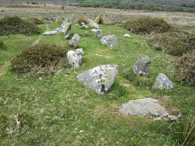
PRN 100700NAME BANC LLWYDLOS TYPE CHAMBERED TOMB PERIOD Prehistoric NGR SN0875133233 CONDITION Damaged STATUS FORM Earthwork

SUMMARY A sub-rectangular shaped arrangement of stones set on edge and protruding through a similarly shaped low earthen mound. Possible the remains of a former prehistoric 'passage grave' or 'chambered tomb', it is situated to the east of a stream on a gentle NE facing slope of Banc Llwydlos.

LONG DESCRIPTION A sub-rectangular shaped arrangement of stones protruding through a similarly shaped low earthen mound. It is situated to the east of a stream on a gentle NE facing slope of Banc Llwydlos at 260m above sea level. The stone setting is aligned roughly N-S and is widest at its southern end where the stones appear to form a 'chamber' up to which a narrow linear 'passage' runs from the north, where there would appear to be an entrance. The feature is 14.2m long and measures 3.6m at its widest southern end and 2.4m at its northern end. It is very similar in construction to Beddyrafanc chambered tomb that lies just over 2.5km to the NE (PRN 1032). The site was first recorded by P Drewett in 1984 as a ‘multiple stone setting – passage grave’ (site no 106). FM & HW April 2011

==============================


PRN 100701 NAME BANC LLWYDLOS TYPE STANDING STONE PERIOD Prehistoric NGR SN087763323 CONDITION Damaged STATUS FORM Stone slab

SUMMARY A possible standing stone recorded by P Drewett in 1984.

LONG DESCRIPTION A possible standing stone recorded by P Drewett in 1984. It is situated to the north of the 'passage grave' PRN 100700, and lies east of a stream on a gentle NE facing slope of Banc Llwydlos at 260m above sea level.

A site visit to the area was undertaken in April 2011. It was difficult to pinpoint which stone, in an area of many scattered stones and boulders, could qualify as this standing stone. However, the most likely would appear to be a stone located at SN08773323, to the north of the 'passage grave' PRN 100700. The stone appears to be placed at the eastern end of a vague earthen linear bank that fades into the gorse to the west. The stone is approximately 0.5m high. This site was first recorded by P Drewett in 1984 as a ‘standing stone’ (site no 107). FM & HW April 2011

====================================


PRN 100702 NAME BANC LLWYDLOS TYPE ENCLOSURE PERIOD Prehistoric NGR SN08813321 CONDITION Damaged STATUS FORM Stone built structure

SUMMARY A small sub-circular enclosure situated east of a stream on a gentle NE facing slope of Banc Llwydlos at 260m above sea level, defined by a number of very large stone blocks, some of which are set within an earthen bank.

LONG DESCRIPTION A small sub-circular enclosure situated east of a stream on a gentle NE facing slope of Banc Llwydlos at 260m above sea level. The site lies c.500m east of the possible 'passage grave' PRN 100700
The enclosure measuring approximately 7.5m N-S and 6.5m E-W. It is of unusual construction, being made of very large stone blocks, some of which are set within an earthen bank. Incorporated within the eastern side of the circle is a large stone slab lying in a horizontal position, that has been levelled by balancing it on several smaller stones below it. The stone slab is 2.6m long and 2.0m wide at its widest point. There is a possibility of an entrance on the western side. This site had not been recorded before this visit and was not included in P Drewetts 1984 report on his Mynydd Preseli fieldwork. April 2011

==========================


PRN 100703 NAME BANC LLWYDLOS TYPE STANDING STONE PERIOD Prehistoric NGR SN08723322 CONDITION Damaged STATUS FORM Stone slab
FM & HW

SUMMARY A possible 'megalith' recorded by P Drewett in 1984. It is situated to the south of the possible 'passage grave' PRN 100700.

LONG DESCRIPTION A possible 'megalith' (site no 124) recorded by P Drewett in 1984. It is situated to the south of the possible 'passage grave' PRN 100700, and lies east of a stream on a gentle NE facing slope of Banc Llwydlos at 260m above sea level.
A site visit to the area was undertaken in April 2011. It was difficult to pinpoint which stone, in an area of many scattered stones and boulders, could qualify as this 'megalith'. However, the most likely would appear to be a large stone boulder located at SN08723322, to the south of the 'passage grave' PRN 100700. The stone boulder is approximately 0.7m wide and 0.7m high, and has a depth N-S of 0.55m. FM & HW April 2011

=========================


PRN 100704 NAME BANC LLWYDLOS TYPE CIRCULAR ENCLOSURE PERIOD Prehistoric? NGR SN08733323 CONDITION Damaged STATUS FORM Earthwork

SUMMARY A possible small circular enclosure visible as a low earthwork.

LONG DESCRIPTION A possible small enclosure visible as a low circular earthen bank with some large stones on the north side of the curve. It is approximately 6.0m in diameter. It is situated east of a stream on a gentle NE facing slope of Banc Llwydlos at 260m above sea level.
FM & HW April 2011

========================


PRN 100705 NAME BANC LLWYDLOS TYPE SHEEP FOLD PERIOD Medieval NGR SN09513302 CONDITION Damaged STATUS FORM Stone structure

SUMMARY A possible sheepfold situated on a northwest facing slope of Banc Llwydlos at 250m above sea level, lying to the east of a stream.

LONG DESCRIPTION A possible sheepfold situated on a northwest facing slope of Banc Llwydlos at 250m above sea level, lying to the east of a stream. It is sub-circular in shape and of dry stone construction whose walls survive to between 4/5 courses high. The enclosure has an approximate diameter of 8.9m. There is an entrance on the west (facing the stream) measuring 1.2m wide. It is possibly a later re-use of an earlier structure. It was recorded by P Drewett in 1984 during field survey and listed as ‘hut cluster (circular stone huts)’ (site no 109).
Depicted as 'sheepfold' on OS County series Pembroke. XI.9 1889 & as 'old sheepfold' on 2nd edition (1907).

===================


PRN 100708 TYPE HUT CIRCLE NGR SN10293297 CONDITION Unknown
NAME BANC LLWYDLOS PERIOD Prehistoric?

STATUS FORM Unknown SUMMARY A 'circular stone hut' identified by P Drewett during field survey in
1984.

LONG DESCRIPTION A 'circular stone hut' (site no 117) identified by P Drewett during field survey in 1984.No more information is listed in Drewett’s 1984 report. Not located during fieldwork in 2011. The grid reference has been estimated from the sketch map contained within the report. FM & HW April 2011

Friday 7 April 2017

Darvill and Wainwright chapter available online


I had not realised it until now, but the big Darvill and Wainwright chapter on the Neolithic and Bronze Age (from the first volume of the Pembs County History) is available online as a PDF.

Here it is:

eprints.bournemouth.ac.uk/26806/1/Darvill%20%26%20Wainwright%202016.pdf

Happy reading! You will need to read it in landscape format, since the PDFs are for double page spreads.

Gallery graves or passage graves?


 Bedd yr Afanc -- not a passage grave, but a gallery grave......


I think it may be wiser to refer to these two features (one at Banc Llwydlos and the other at Penanty-isaf) as potential gallery graves, rather than passage graves.  I'll adjust the titles of the posts accordingly.

According to the big chapter by Darvill and Wainwright in the latest Pembs County History series, Neolithic passage graves were generally chambers covered by substantial mounds with one access passage within.  The passage was just a means of access to the chamber used for burials. They may have had side chambers used for the placing of corpses or bones or cremated remains. Gallery graves, on the other hand, may not have had large covering mounds looking like round barrows or long barrows, although they may have had a complete elongated "roof" made of slabs or capstones. Some are wedge-shaped.  Burials took place in the elongated gallery.

Bedd yr Afanc is classified as a gallery grave, while Cerrig y Gof, near Newport, is classified as a passage grave with a cluster of internal chambers.  Others refer to it as a chambered tomb. (I'm not sure why Darvill and Wainwright (p 92) refer to it as a passage grave, since there was apparently no internal passage.......... but we'll let the experts argue about that....)

It's wise to go with the flow here so as to avoid confusion.  It's clear that the Banc Llwydlos and Penanty-isaf features are nothing like Cerrig y Gof or the other dolmens or portal tombs of west Wales (for example, Carreg Coetan Arthur or Pentre Ifan) -- but they are very similar to Bedd yr Afanc.

Wikipedia definitions:

Passage grave --a prehistoric megalithic burial chamber of a type found chiefly in western Europe, with a passage leading to the exterior. Passage graves were originally covered by a mound, which in many cases has disappeared, and most date from the Neolithic period.

Gallery grave -- an underground megalithic burial chamber which may be divided into sections but has no separate entrance passage.

Thursday 6 April 2017

Penanty-isaf gallery grave


This feature is a little more than 1 km from the Banc Llwydlos gallery grave, to the NW and further down the Afon Pennant stream.  It's located on boggy grassland, about 20m from the most prominent hawthorn tree on this part of the common.  Another smaller hawthorn tree is also 20m away.  The boundary of the enclosed land belonging to Penanty-isaf  Farm is about 150m away.

Like the Banc Llwydlos feature, this one is about 12 m long, with a "passage" or "gallery" about 1 m wide.   The alignment of this one is quite different, with a closed end to the NW and the open end to the SE.  About 31 boulders are visible, but here they are not set in prominent ridges -- the ridges are no more than 20 cms high.  Also, the grassy passage is at the same level as the surrounding grassland.  The eastern row of stones appears complete, but the western row is much shorter.   Could it be that this feature was started and never finished?

It certainly looks like a relative of the features at Bedd yr Afanc and Banc Llwydlos, but maybe we should refer to it as a proto-gallery grave, or some such thing.......

Grimes originally interpreted Bedd yr Afac as a wedge-shaped feature like those of southern and eastern Ireland.  Is this one wedge-shaped as well?    Not sure about that..... 

Grid ref:  SN 09560 33896


Banc Llwydlos gallery grave


Thanks to Emyr Jones and others, I was encouraged to go on a gallery grave hunt today, and sure enough I found the one which has been discussed at some length on Facebook and elsewhere.  I'm no expert on gallery graves, but I am convinced -- and I hope that the experts will go and take a look at it..........

The grid reference for this is approx SN 087332 -- it's about 50m NW of the Banc Llwydlos cromlech, and about 100m downslope of the recently burned area.  It is also about 250m from the long fence of the enclosed land belonging to Tafarn y Bwlch.  About 30m to the NW there is a stream gully, but the grave site itself is on dry and grassy land.

The feature is about 12m long, with its open end to the N and its closed end to the S. The "passage" is about 1m wide, and the raised banks are each about 1m wide, revealing many exposed boulders.  The grassy "gallery"  is about 50 cms above the level of the surrounding grassland.  Around 35 boulders are visible in the embankments.  The closed end is about 2.5m wide, and the banks converge towards the open (northern) end.  So there is a wedge shape, as at Bedd yr Afanc.  To the east of the eastern bank there are two large "outlier" boulders -- maybe they are in their natural positions.

Was this feature a real gallery grave, with supported slabs or capstones along its full length?  Maybe -- and maybe these fallen slabs are buried beneath the turf.  Excavation needed!  There are certainly a lot of similarities with Bedd yr Afanc, which is about 2.5 km away.

The site has been investigated by Murphy and Wilson (2012) and is also referred to by Darvill and wainwright on p 93 of the latest Pembrokeshire County History volume.

Postscript - More info

I have discovered this in another excellent Dyfed Archaeology publication:

DYFED ARCHAEOLOGICAL TRUST
REPORT NO. 2012/6  PROJECT RECORD NO. 100689
January 2012
SCHEDULING ENHANCEMENT PROJECT 2011: PREHISTORIC SITES FIELDWORK
– PEMBROKESHIRE ADDITIONAL SITES

Fran Murphy & Hubert Wilson

www.dyfedarchaeology.org.uk/projects/schedulepembroke2011.pdf

Extract for Banc Llywdlos:

PRN 100700 is a possible ‘passage grave or chambered tomb’. It is situated to the east of a stream on a gentle NE facing slope of Banc Llwydlos at 260m above sea level. The stone setting is aligned roughly N-S and is widest at its southern end where the stones appear to form a 'chamber' up to which a narrow linear 'passage' runs from the entrance at the northern end. It is very similar in construction to the scheduled ancient monument Bedd yr afanc chambered tomb that lies just over 2.5km to the northeast (PRN 1032, SAM PE122), and in the same topographical position on the edge of boggy ground.
The site was recorded by P Drewett in 1984 as a ’multiple stone setting/passage grave’ but had not been recorded on the HER before now.

Here is the plan drawn up by Murphy and Wilson:


Here is the map of the area, as published in the Report:


Note that Murphy and Wilson refer to PRN 100700 as a ‘passage grave or chambered tomb’ -- it's clear that there are considerable differences over terminology!

Note also that 4 features are shown very close together around position PRN 100700 -- the Banc Llwydlos "cromlech" is one of these.

Banc Llwydlos cromlech (1)


I wonder how many undiscovered cromlechs there are in Pembrokeshire?  Not many, I suppose.  Anyway, I found one of them today, while hunting for Neolithic passage graves on Brynberian Moor.  I have checked, and can find no record of it on Coflein, Archwilio or any of the other sites.  If somebody knows about it already, please get in touch, so that we can share info.......

I imagine that at the height of summer, the nettles and rushes will be much higher, making this capstone quite difficult to spot from a distance.

It's rather a nice little cromlech, located on a slight morainic ridge of dolerite boulders, some of which are up to 5m long, and deeply embedded in the ground.  Grid reference SN 088332.    I didn't have time to survey it accurately, but it is an "earthfast dolmen" with a flattish capstone about 2.5m long, with one end embedded in the ground and the other propped up in rather a complex fashion,  resting partly on a dish-shaped slab of dolerite about 1.5m long and partly on a smaller stone with dimensions 30 cm x 10 cm x 10 cm.  I think that is too complex an arrangement to have occurred by chance in a glacial environment -- so my conclusion is that the big slab has been used where found, with one end levered up (probably with the aid of long logs) and then supported by these two stones.   There are actually other smaller stones supporting the larger of the two supports.  

The capstone is about 60 cms thick at the earthfast end, and about 30 cms thick at its propped end.  The "entrance" or propped end of the chamber points roughly northwards. 

It is possible that in the past human beings could have crawled beneath the capstone into a chamber which is currently demarcated by an almost circular ridge or embankment.  This latter feature cannot be natural either -- it is perfectly obvious when you scramble around on it. 

The embankment is about a metre high, with many large stones projecting through the turf.  Again, big erratics have been used where found, with smaller stones packed between them.  The hollow adjacent to the capstone is very clear too.  The diameter of the whole embanked structure is about 6m. 

Was there a mound with a chamber beneath it?  It's possible.  My impression is that this is a very primitive feature (Early Neolithic?) built opportunistically in a place where all the stones needed were available on the spot.  All of the stones are dolerite, except for a small slab of mudstone which is found in the "entrance" to the tomb -- could it have been a portal or movable doorway?

The only other record that we have for Banc Llwydlos is this one, from Dyfed Archaeological Trust, relating to a cluster of huts not far away.  Are the features all related?

I'll do another post on the assumed "passage grave" (about 50m away) which I also had the opportunity to examine today.........


=======================


DYFED ARCHAEOLOGICAL TRUST
PROJECT RECORD NO. 96851
March 2010
SCHEDULING ENHANCEMENT PROJECT 2010: PREHISTORIC SITES FIELDWORK – PEMBROKESHIRE
By F. Murphy, M. Page, R. Ramsey and H. Wilson

PRN 14373 NAME BANC LLWYDLOS TYPE UNENCLOSED SETTLEMENT PERIOD Prehistoric NGR SN08973303

CONDITION Damaged

STATUS NPP

FORM Earthwork complex

SUMMARY A settlement complex including at least seven hut circles surrounding a square enclosure and yard, situated on the northeast facing slope of Banc Llwydlos.

LONG DESCRIPTION A settlement complex including at least seven hut circles surrounding a square enclosure and yard, situated on the northeast facing slope of Banc Llwydlos at 270m above sea level. Indentified from aerial photography in 1990, 2009 saw the first site visit and this recorded a settlement complex of possible prehistoric date. The complex includes seven hut circles that are spread around a small square shaped enclosure. The square enclosure measures approximately 6.0m E-W by 5.0m and has an entrance on the north. The
entrance leads out to a small 'yard' area that has an opening on the east into a larger rectangular 'yard' area measuring 18m E-W by c.6.0m. These yards appear to have been constructed on a platform to create a level area on the sloping ground, and much of the settlement has the appearance of being somewhat terraced into the hill slope. The hut circles vary from 5.5m to 3.5m in diameter. All the features are defined by low, spread, stony earthen banks that have an average height of 0.3m and an average width of 1.3m. All the banks are grass covered and many have large stones protruding through the turf. 350m to the east is another hut circle group PRN 1565 that has been scheduled. FM & RR June 2009
A stone banked series of features including one or more possible huts with linking walls. Noted by CRM during air survey. TAJ 21:2:1990.


The great passage grave hunt


Passage graves?   Photos:  courtesy Emyr Jones


Following a mention in one of the local archaeology newsletters, there has been a flurry of activity here in North Pembrokeshire as people of all ages and levels of expertise go off hunting for passage graves on Brynberian Moor.  I was alerted to this by Emyr Jones, who has stimulated a lot of discussion on social media.

The approx grid references for the features found by Emyr and his friends are SN 095338 and SN 087332.  One of the features is near a prominent hawthorn tree on the moor, and the other is not far from the edge of a recently burnt area.

This is a part of the moor which is not visited very often, lying on the flank of the great moraine which I have described in earlier posts in the vicinity of Tafarn y Bwlch.  On the OS map the area is referred to as Banc Llwydlos.

I shall go and take a look, and report back......


Above is a Google earth image of the Banc Llwydlos area -- a big and boggy wilderness area of several sq km with extensive tracts of gorse, bracken and wetland.  Needle in haystack territory -- but this is the best time of year to go searching, before the bracken gets high.

On the image above Tafarn y Bwlch is on the extreme left, and the big farm is Penanty-isaf.  The stream catchment is that of the Afon Pennant, which flows down towards Brynberian vallage and the Brynberian river gorge.


Tuesday 4 April 2017

The creation of the Straits of Dover


 https://www.researchgate.net/blog/post/britain-would-still-be-attached-to-europe-had-this-ridge-remained-intact


This is an interesting article -- I have not yet managed to read the original in "Nature Communications".  The idea of the Ice Age megaflood draining a pro-glacial lake in the southern North Sea is an old one, and Gupta and his colleagues have been reporting on the essentials of this work for more than 10 years now.  What is new is the linking of the megaflood event with the gigantic depressions (up to 100m deep) close to the position of the old chalk ridge that ran across from one side to the other.  They are now interpreted as plunge pools created by enormous volumes of meltwater cascading over the low points in the ridge.

On the illustration above, note the herd of rhinos..... nice touch!

It looks as if the original breach of this chalk ridge is now assumed to have occurred at the end of the Anglian Glaciation, around 500,000 years ago.   We have talked rather a lot about that particular glaciation on this blog.......

It's always good to see some serious glacial geomorphology given some publicity by the BBC and other media -- but calling the "megaflood event" an Ice Age Brexit really is taking things a bit far.  Has the whole world gone bonkers?  Well, yes........